Content:
SeaDataNet is
a major operational infrastructure for managing, indexing and providing access
to ocean and marine data sets and data products, acquired by European
organisations from research cruises and other observational activities in
European coastal marine waters, regional seas and the global ocean. It develops,
governs and promotes common standards for metadata and data formats, controlled
vocabularies, quality flags, and software tools and services for marine data
management, which are widely adopted and used for improving FAIRness (Findable,
Accessible, Interoperable and Reusable). SeaDataNet core partners are the
National Oceanographic Data Centres (NODCs) and major marine research
institutes in Europe. It has established a large European and international
network, working closely together with operational oceanography, marine
research, and marine environmental monitoring communities as well as with other
major marine data management infrastructures. SeaDataNet is a major partner in
the development and operation of the European Marine Observation and Data
network (EMODnet),
aimed at supporting the EU initiatives on Marine Knowledge 2020 and Blue Growth
and the Marine Strategy Framework Directive (MSFD). SeaDataNet has a close
cooperation and MoU with Copernicus Marine Environmental Monitoring Service (in
particular CMEMS-INSTAC). Since
the mid-1990s, SeaDataNet has expanded and matured and currently provides
federated discovery and access to more than 110 data centres for physics,
chemistry, geology, bathymetry, and biology. As part of the EU HORIZON 2020 SeaDataCloud project, SeaDataNet is
further developing its discovery, access, ingestion, publishing and
visualisation services as well as its widely adopted SeaDataNet
standards. The project aims at upgrading
and expanding the SeaDataNet architecture and services, making use of cloud
services, taking into account requirements from major stakeholders, such as
EMODnet, CMEMS, EuroGOOS, EU Directives such as MSFD, MSP, and INSPIRE,
international cooperations, such as ICES, IOC-IODE, GOOS, GEOSS, and the European Open Science Cloud (EOSC)
challenge. The SeaDataCloud project is implemented in a partnership with EUDAT,
a leading European network of academic computing centres, who are well involved
in the EOSC developments. The major objectives of the SeaDataCloud project are:
- Improve discovery and access services for
users and data providers
- Optimise connecting data providers and their
data centres and data streams to the infrastructure
- Improve interoperability with other
European and international networks to provide users overview and access
to additional data sources
- Develop a Virtual Research Environment
with tools for analyzing data and generating and publishing data products
- Development,
update and publication of data products for European sea regions.
This is the fourth edition of the newsletter in the
framework of the SeaDataCloud project. It gives you information about the progress
of a number of SeaDataCloud developments such as the launch of the upgraded CDI
data discovery and access service, the near finalization of the prototype
SeaDataNet Virtual Research Environment, the delivery of the SeaDataNet SWE
Toolkit for managing operational oceanographic data streams from input to
storage to distribution and visualization, how SeaDataNet is contributing to
the Ocean Standards & Best Practices initiative of IOC-IODE, and other
topics. We hope you will enjoy this newsletter and will be triggered to visit
the SeaDataNet portal for a try-out of its services and to follow its
evolution. We aim to reach as many people as possible, so please forward it to
anyone you know may be interested.
A major focus of the SeaDataCloud
project has been directed towards upgrading the SeaDataNet Common Data Index (CDI) service
for
discovery and access to a wealth of marine and ocean data. In October 2019,
the joint developments of the SeaDataNet network of oceanographic data centres and
EUDAT, a leading European network of academic computing centres, have resulted in the launch of a new and innovative
version of the CDI service. It replaces the previous version which has been in
operation since 2015, while the ur-version was already released in 2007.
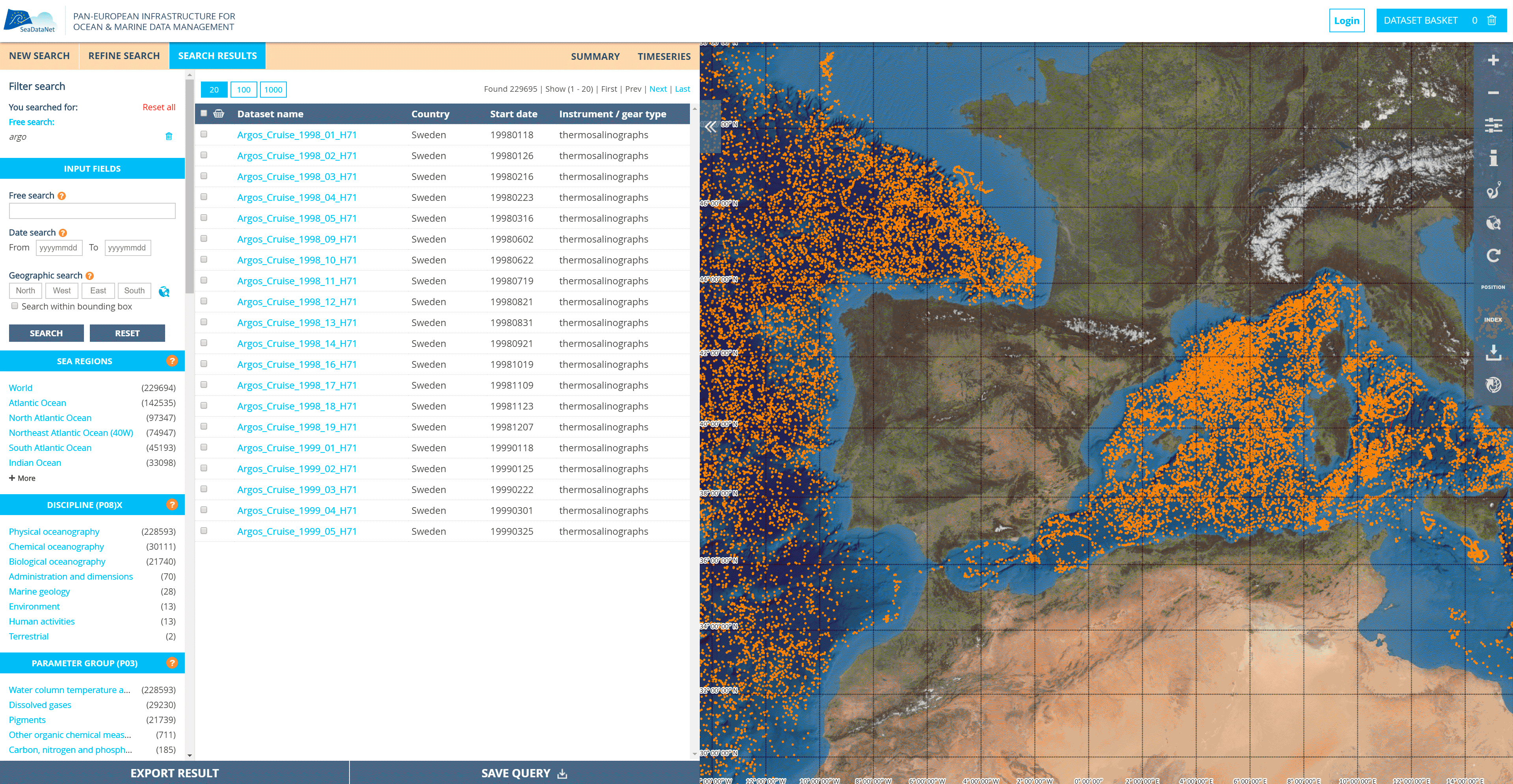
Image:
New dynamic user interface of the upgraded CDI data discovery and access
service, giving discovery and access to more than 2.3 million data sets from 110
data centres
Architecture:
The
new architecture of the CDI service makes a distinction between the front-end
with discovery, shopping and downloading of data sets by users, and the back-end
for importing new and updated CDI metadata and related data entries (including
versioning) by data centres. The separation is achieved by introducing a
central data cloud, which holds copies of all unrestricted data sets by
replication from the connected data centres, and which serves as a central data
cache for efficiently executing user shopping requests.
New CDI service components
-
Local software tools at data centres to
prepare metadata and data files in SeaDataNet formats and using SeaDataNet
controlled vocabularies, from local data resources
-
Replication Manager at data centres for
importing CDI metadata to Central CDI catalogue and associated data
files to Data Cache cloud, orchestrated by the CDI Import Manager
-
Data Cache cloud with adapted EUDAT
services for import, storing, and downloading
-
Upgraded CDI User Interface and facilities
for shopping and tracking of shopping requests, by users and data centres
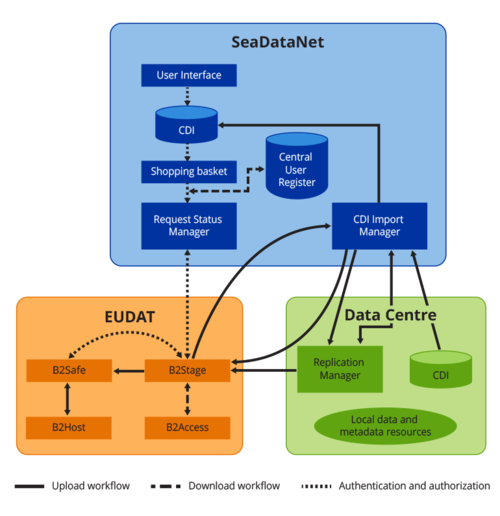
Table: Architecture of upgraded CDI service
GUI
and MySeaDataNet:
The interface is intuitive, but in case of questions an on-line help is available.
The
Graphical User Interface gives users powerful search options by combining free
search, facet search and geographic search options, powered by Elastic Search,
SQL search, and Geo Server. The data access function comprises a simple and
effective data shopping, tracking and download service mechanism. All
functions for both users and data providers can be reached from a new
MySeaDataNet dashboard, depending on the Marine-ID and associated registered
functions and roles. As part of this, the shopping process now has an integrated
dialogue instead of having to go to separate applications and URLs, for example
for searching, registering, checking shopping progress, and retrieving data
sets. This makes the dialogues for users and providers much more efficient, and
easy to understand and perform. Furthermore, several processes and
functionalities have been reviewed and optimised, including performances, which
again is in favour of the users and data providers.
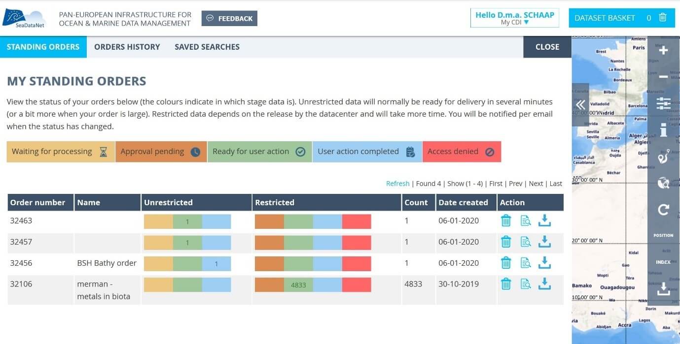
Image: Example screen of the shopping
dialogue of the upgraded CDI service
For data centres, the MySeaDataNet environment gives access
to an online CDI Import Manager service with a dashboard to manage imports of
new and updated CDI and data entries. And it gives data centres the option to
evaluate and process shopping requests for restricted data sets, which are
managed locally and not in the central data cache. The import of metadata and
unrestricted data as well as the delivery of restricted data sets, once agreed,
are structured as workflows and more self-service oriented as in the current
situation. These services work together with the Replication Manager for
efficient automatic processing. The Replication Manager replaces the Download
Manager, and is easier to install and configure if done by technicians who are
well aware of their local infrastructure. Alternatively, the semi-automatic
‘interim solution' is maintained for data centres that are not allowed to
install a local component. However, extra functionality is added to the CDI
Import Manager for the CDI support desk to mediate for ‘interim' data centres
to maintain the CDI catalogue, now both with unrestricted and restricted data
sets. This gives ‘interim' data centres the option to relax their data policies
and to provide unrestricted data sets. While moving from interim to a situation
with Replication Manager is an option which adds to further streamlining the
processes.
SeaDataNet role and position in the
European marine data landscape:
The CDI service is instrumental for the position and
importance of SeaDataNet in the marine and ocean domain. SeaDataNet plays a leading
role in the European marine data management landscape, next to and in
cooperation with other leading European infrastructures, such as European Marine Observation and Data network (EMODnet)
and Copernicus Marine Environmental Monitoring Service (CMEMS). The SeaDataNet network of National Oceanographic
Data Centres (NODCs) and data focal points provides essential connections and
functionality at national levels in Europe to the many originators of marine
observation and analysis data. The more than 100 SeaDataNet national data
centre nodes manage, store, quality control, curate, and distribute ocean and marine
data sets, for physics, chemistry, geology, biology, and geophysics. The
original data are collected during research cruises, national monitoring
programs, scientific projects, and other observational activities in European
coastal marine waters, regional seas and the global ocean. The originators are more
than 750 organisations, such as marine research institutes, monitoring
agencies, geological surveys, hydrographic services, universities, and private
sector, who use the SeaDataNet data centre nodes for long-term archival and
wide distribution.
The SeaDataNet CDI Data Discovery and
Access service gives harmonized discovery and access to this large and
ever-increasing volume of marine and ocean data sets as handled and managed at
the SeaDataNet data centre nodes. The archived and curated data, increasingly
are major input for developing added-value services and products that serve
users from government, research and industry. Major products are developed by
EMODnet lots, CMEMS, and SeaDataNet itself. For instance, EMODnet Chemistry
delivers harmonized and validated aggregated data collections for
eutrophication, and contaminants for all European sea basins which serve the
Marine Strategy Framework Directive (MSFD) and are taken up by Regional sea
Conventions, EU DG-Environment and European Environment Agency (EEA) for
supporting assessments and deriving indicators. The data as harmonised and
bundled by SeaDataNet provides the initial basis and facilitates regular
updating of those EMODnet products as new data are becoming available. On its
turn, EMODnet stimulates more originators of data, and more data centres to
join the SeaDataNet network of data centres and the CDI service for including
their original observation and analysis data sets, this way expanding and
strengthening the basis under the products and improving their quality. CMEMS
deploys pan-European capacity for Ocean Monitoring and Forecasting. SeaDataNet
and CMEMS have an MOU in place for mutual exchanges of data, adoption by CMEMS
of SeaDataNet standards, and for developing joint products such as
climatologies. Next to serving organised communities, the SeaDataNet CDI
service also serves individual users, mostly from research sectors. This is
further stimulated, inter alia through cooperation with the evolving European
Open Science Cloud (EOSC).
Optimising the robustness and performance of the new CDI service:
During the SeaDataCloud developments, major attention was given to the
fine-tuning and further integration of the individual system components,
deploying various use cases, including upscaling of numbers and volumes of
imported and retrieved data files, and monitoring the behaviour and functioning
of the processes aiming for operational stability and ruling out interruptions
and failures. During the
tests, performances were administered and tuning was undertaken to bring
performances to an acceptable level. The tuning incorporated arranging more
computing resources, such as more CPU's, workers, and memories, as well as
making processes faster and more efficient. Also, a lot of activity was undertaken for fine-tuning and completing
interfaces and communications for and to data providers and end-users. A lot of
interaction was undertaken by organizing two sessions of training for data managers and technicians on
common standards, data management procedures, and installing and using upgraded
system components and tools. The first training workshop gave
technicians and data managers of data centres a preview of the new CDI user
interface allowing data centres to test a beta version and to provide feedback
about their findings and suggestions. This feedback was great input for further
developing and fine-tuning the new CDI user interface. The second training
workshop gave data centres more details and hands-on training with the further
developed import procedure and how to deploy the Replication Manager at their
data centres in order to migrate from the old CDI system with Download Manager
to the new CDI system configuration. This gave insights for improving
installation and configuration instructions and manuals of software components.
This second training workshop was also an important event as part of the
process for wider deployment of the new CDI service at each of the more than
100 CDI data centres. During this migration process of several months further
feedbacks were provided about bugs and topics for improvement, leading to new
releases of the Replication Manager software and upgrading of the services,
operated by SeaDataNet partners and EUDAT. Moreover, the system for operational monitoring of the
upgraded components of the CDI service and the new components, in particular on
the EUDAT platform, needed to be upgraded.
Different environments have been set-up for development, test
and production. This applies to the components as given above for the
SeaDataNet and EUDAT platforms, while for Data Centres no development environment
is included, but only test and production. This separation in environments
makes it possible to undertake additional developments, which are moved to the
operational test environment for integrated testing, followed by moving to
operational production. The test environment at Data Centres serves to install,
configure, and test new versions of the Replication Manager, while the old
stays in production till it can be replaced.
Future developments:
Further upgrading of the CDI service is
undertaken in synergy with the ENVRI-FAIR project. This is in particular aiming
at improving the FAIRness of the service, both by enriching metadata and by
optimizing machine-to-machine services. For this, SeaDataNet is introducing
SPARQL endpoints for all its European directories and common vocabularies,
adopting common patterns, following the Linked Data principles. SPARQL is a W3C standard and the query
language used to query Resource Data Framework (RDF) data. Linked Data
representations of the various SeaDataCloud catalogues will allow ease of
interoperability at a global scale. In addition, using these principles and
services, the CDI metadata can be enriched automatically by making use of
additional metadata from the linked SeaDataNet directories and possible other
external sources, such as DOI landing pages for scientific papers. This will be
deployed for enriching the discovery and detail pages, while also a CDI API is
under development, making full use of the Linked Data model.
Try it out
yourself and customer survey:
You are invited
to try out the upgraded service yourself, starting at the CDI service landing page .
Discovery and browsing of metadata are
public, while a one-time user registration is required for submitting data
requests. If you do, we also ask you to complete a short survey, which you can
find with a button in the top bar. The survey results will help us to understand how well
the service is working and what might need to be improved in the future.
For researchers, the conventional work using
their desktop computer to analyse data and generate products is getting more
and more tedious due to the increasing amount of data to process and the
complexity of the procedures. Three main hurdles often prevent them from
performing the required operations:
- Insufficient
CPU power, leading to excessively long computation times
- Lack
of available memory to process large datasets
- Insufficient
disk storage, making the use of the full datasets impossible.
To overcome these, cloud services are becoming
common practice, such as the EUDAT European Research Data Infrastructure or the European Open Science Cloud
(EOSC). With
such services, no more data downloading is needed: all the processing is
performed close to the data. In
addition, the cloud allows research on a common platform, with a guarantee that
the latest versions of the software tools are installed, and enhances the
reproducibility of the scientific work. In order to gain experience with
web-based science and to provide the oceanographic community with seamless
access to SeaDataNet data and software tools, the SeaDataNet Virtual
Research Environment (VRE) prototype has been developed and
deployed.
SeaDataNet VRE tools overview:
Users with an account can login to the VRE with
their Marine-ID, the
SeaDataNet identity provider, and then enter a dashboard with access to a
private workspace as well as the different services which are described
hereinafter.
webODV consists of a suite of online services based on the Ocean
Data View (ODV) software, designed to interactively perform
analysis, exploration and visualization of ocean data. webODV allows users to
aggregate large numbers of SeaDataNet data files and perform quality control. DIVAnd
(Data Interpolating Variational Analysis in n dimensions) is a cutting-edge software tool designed to
efficiently interpolate in-situ observations onto a regular grid, in an
arbitrary number of dimensions (for instance longitude, depth and time). A set
of Jupyter notebooks
provides a guideline to the user on how to prepare the data, optimise the
analysis parameters and perform the interpolation. BioQC is a tool to process and to run quality control on biological
datasets. BioQC helps researchers to evaluate whether a particular biological
occurrence record within the input file is useful for their analysis. It also
helps the data providers to identify possible gaps and errors in their datasets.
The tool returns the input file with quality information attached for each
occurrence record and a detailed report. This result file will enable the users
to filter for suitable records. VIZ
is a modern and dynamic visualisation service to explore datasets on a map. By
clicking on data points, the users see a plot of the full profile prepared with
WebODV, and metadata of the input ODV files. A time selector makes it possible
to limit the data for the period of interest. Additionally, the visualisation
service provides the possibility to explore 4D gridded products prepared with
DIVAnd.
The Subsetting
service based on Erddap strives to make data access easier, by providing
services to subset, download and plot data. It returns datasets in various data
formats such as CSV, MATLAB, netCDF, ODV and more. An interactive visualization
tool allows users to discover and browse through the subset results with modern
web technologies.
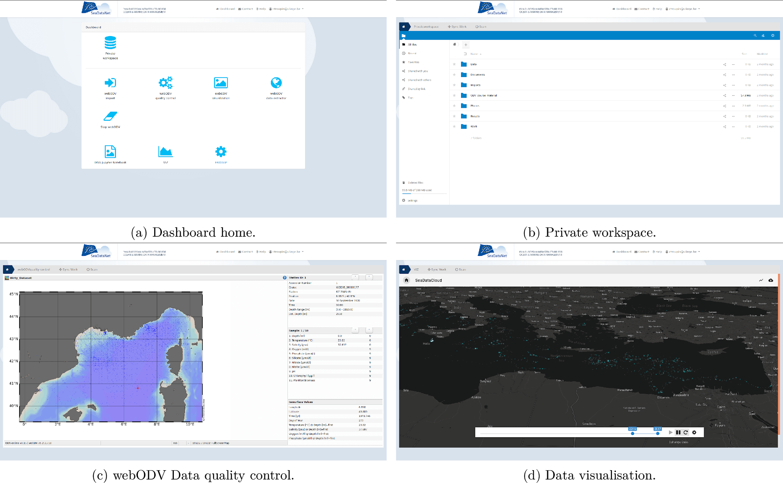
Image: Different components of the VRE.
How is the Virtual
Research Environment deployed?
The VRE's components are deployed on different
servers across various EUDAT data centres to distribute the load. The shared
central components as well as the various processing services are deployed as Docker containers. These provide a standardized computing
environment across all data centres and significantly facilitate the
development of the VRE. The services are loosely coupled: the VRE provides
central services such as Single Sign-On and central web storage for users, but
the services can also run as standalone services. This allows one to easily
extend the architecture and integrate heterogeneous services.
The dashboard is the heart of the VRE.
Besides providing the main user interface, it is responsible for managing
diverse aspects of the VRE. It provides the user interface with access to the
different services and to the user's private workspace, an online storage space
for users to store their own datasets and the results of their analysis.
Additionally, the dashboard performs some tasks behind the scenes: it is
responsible for triggering data synchronisation mechanisms and ensures user
authorization for the various services by a token-based authorization system. The dashboard is a web application based on the PHP framework Laravel, which
includes a user management system and implements state-of-the-art security
measures. The authentication/ authorization protocol OAuth is used to provide
Single-Sign-On authentication with Marine-ID, based on EUDAT's B2ACCESS, an
authentication service used by several European projects and initiatives. The private workspace is an instance of
the well-known NextCloud tool, an open source software for cloud-based
collaboration. It is customized for the SeaDataNet VRE and runs on its hardware.
The file selector is a bridge
between most VRE services and the user's private workspace, allowing users to
select data from their private workspace to be handed over to the service
instances by the back end. Its front end is based on hummingbird-treeview, a
JavaScript tool for displaying lists or file/folder structures as hierarchical
trees. Services can customize the treeview to their needs.
Two types of
processing services:
The actual processing tools - the services - are what researchers use to perform their analyses. Two types of
services are deployed in the VRE. Some services operate like traditional web
servers, where one central instance serves all users' requests. The BioQC tool, the VIZ-ualisation
tool, and webODV are examples for this type. For these
services, one Docker Container is running continuously and waiting for users,
and the work of different users is kept separate using http sessions. This is
the first type of service.
The second type of service is for the more
computation intensive tools or those whose backing software is not optimized
for separating multiple user's sessions. The latter frequently occurs when porting
software that was developed for desktop machines to the cloud-based mode. This
type of service requires one instance for every user. As services are packaged
as Docker containers, this means that one docker container per user is deployed.
JupyterHub is used to spawn the containers upon the user's request. JupyterHub
is initially developed to serve Jupyter notebooks, but - slightly diverting
from its intended use - it can be used for any tool that is packaged as Docker
Container and interacts with the user via HTTP. JupyterHub's benefits include
instance management, authentication/authorization, and solid web security
measures such as reverse proxying and SSL termination. This solution is used
for the services DIVAnd, which is actually run as Jupyter notebooks, and ERDDAP
subsetting service.
DIVAnd tool is provided
to users through a Docker image that includes the installation of
the Julia language (currently version 1.4.0) along with packages such as PyPlot (plotting
library), NCDatasets (manipulation
of netCDF files); required libraries and tools (e.g. netCDF, unzip, git), the
master version of DIVAnd.jl and the
master version of the DIVAnd notebooks.
The VRE's subsetting service embeds an instance
of Erddap, configured dynamically and started on the
fly according to a dataset selected by the user. The service provides a
consistent way to create and download subsets of scientific datasets in netCDF
format. The subsetting service's Docker image includes the installation of Java
and Python for the web services and a web server to run applications (Tomcat),
the Erddap web application, a visualization frontend using VueJS framework,
plus some further required libraries and tools (e.g. netCDF).
Future perspective
In the final year the SeaDataNet VRE prototype will
be further tested by user communities to better suit their needs and to fix
performance issues. The VRE prototype will also be brought to operational level
and actively monitored. After that it will be released under the SeaDataNet website for wider user tests with sufficient
instruction about the tools the user can expect, and with a request to provide
feedback and suggestions for improvement. These suggestions and feedback will
be used as a basis for further development in future projects.
In
the framework of the SeaDataCloud project, the WP11 team is mainly dedicated to
generating data products such as temperature and salinity data collections and
climatologies for the EU marginal seas (Mediterranean, Black Sea, North
Atlantic, Baltic Sea, North Sea, Arctic Ocean) and the global ocean. The goal
is to provide the best data products from SeaDataNet at regional and
global scale and serve diverse user communities (operational oceanography,
climate, marine environment, institutional, academia). The regional aggregated
data sets for all EU marginal seas contain all temperature and salinity data
harvested from the SeaDataNet infrastructure. The data sets are then validated and
elaborated by regional experts. The resulting datasets are used to produce the
climatologies, gridded fields obtained through DIVAnd mapping tool and
representing the climate of the ocean at regional and global scale. In addition
to these standard products, new data products are planned by the end of the
project, in which the WP11 team will explore a multi-platform and
multi-disciplinary approach combining in situ (e.g. gliders, Argo, ships,
drifters, fixed platforms) and remote sensed observations, Ocean Monitoring
Indicators for tracking ocean mechanisms and/or climate mode's and trends. The
WP11 team is making full use of the data sets as available in SeaDataNet and of
many of the services and tools which are provided by the SeaDataNet
infrastructure for discovery, access, validation, quality control,
visualization, interpolation, and gridding of retrieved data sets. This way,
the WP11 team is contributing to verifying the quality of the SeaDataNet
infrastructure content and services. As such it is also involved in the
SeaDataNet VRE development as test team.
Quality Assurance Strategy:
The SeaDataNet partnership has worked
jointly to implement and progressively refine a unique Quality Assurance
Strategy (QAS), shown in the image below, aimed at continuously improving the
quality of the database content and creating the best data products. The QAS
consists of four main phases:
-
all data and metadata are harvested
from the central Common Data Index (CDI) service, using an internal buffer
system, configured for specific subsettings;
- file and parameters are aggregated to
generate a metadata enriched ODV (Ocean Data View) collection;
- Quality Check (QC) analysis by
regional experts on the regional ODV collections further validates (secondary
QC) the data and the Quality Flags assigned by data providers (primary QC);
- analysis and correction of the
detected data anomalies from NODCs (National Oceanographic Data Centers), which
finally updates the corrected data within the infrastructure. The approach is
iterative to continuously upgrade the quality of database content and data
products.
Phases
2 and 3 rely on ODV
software
for the aggregation and quality check of data further developing the the
guidelines introduced within SeaDataNet projects. The WP11 team provides also
recommendations for the development of ODV software and its webODV version. The
phase 3 output consists of validated aggregated data sets for all EU marginal
seas in ODV collection format. These data sets are used to compute temperature
and salinity climatologies through the DIVAnd software tool which allows to
spatially interpolate observations on a regular grid in an optimal way. WP11
team contributes also to the DIVAnd software by an intense testing and
debugging activity.
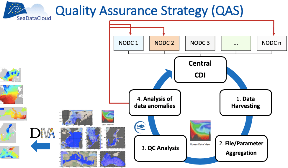
Image: SeaDataCloud Quality Assurance Strategy.
The first version of the aggregated and validated temperature
and salinity data collections (SDC_DATA_TS_V1)
has been
released in June 2018 and they are accessible through the SeaDataNet products catalog
together with their Product Information Document (PIDoc) containing all
specifications about product's generation, quality assessment and technical
details to increase the user's confidence and facilitate products uptake.
Digital Object Identifiers (DOI) are assigned to products and relative PIDocs
following the linking data approach to foster transparency of the production
chain and acknowledge all actors involved from data originators to product
generators. An example, the Mediterranean Sea - Temperature and salinity
Historical Data Collection and its PIDoc, is displayed below.
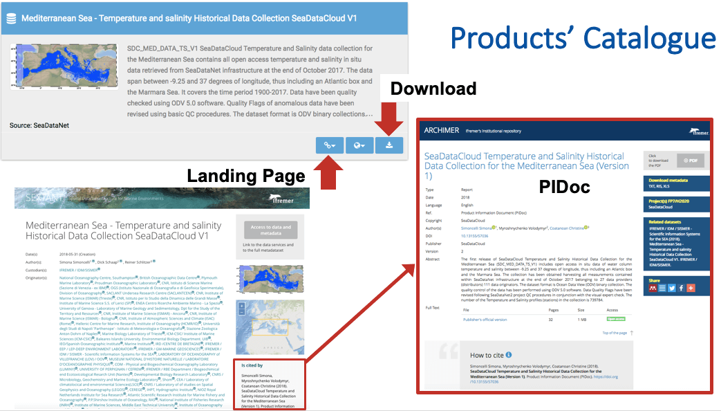
Image: How to access SeaDataCloud products and the relative
Product Information Document (PIDoc) from the SeaDataNet products catalogue
The main
outcome from the analysis of the SDC_DATA_TS_V1
regional collections were:
-
Data
population statistics per sea basin showed a progressive increase of available data
(see next image)
-
Data
quality also improved thanks to the introduction of additional checks by
regional experts
-
QF statistics
after QC present very high percentages of good data
-
New metadata statistics about data distributors/originators highlighted
some systematic
(format, flagging) errors but also made possible to include a fair acknowledgment to all
data providers.
-
New instrument type statistics made possible to
detect some data and
metadata omissions within
the SeaDataNet.
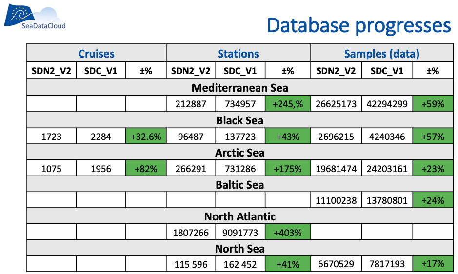
Image: Summary
statistics of SeaDataNet database progresses from SeaDataNet2 to SeaDataCloud
in terms of number of cruises, stations and measurements per sea basin.
The
first version of temperature and salinity climatologies (SDC_CLIM_TS_V1) have
been released in July 2019. The regional
climatologies were designed with a harmonized initial approach, all covering
the time period after 1955 when marine data started to be sufficient for
mapping at regional scale and adopted the World Ocean Atlas 2018 vertical
standard levels. All regional products are characterized by a monthly
climatological field covering the entire time span 1955-2014 at least (some of
them reach 2017) and decadal climatologies at seasonal temporal resolution
(monthly for the Baltic region) over six decades (1955-1964, 1965-1974,
1975-1984, 1985-1994, 1995-2004, 2005-2017). Moreover, all of them have been
created integrating, for the first time, SDC_DATA_TS_V1 aggregated datasets
(both restricted and unrestricted) with external sources (World Ocean Database
and Coriolis Ocean Dataset for Reanalysis), which highly increased the data
coverage.
Also
a global climatology (SDC_GLO_CLIM_TS_V1) has been created for the first time
which contains two different monthly climatologies for temperature and
salinity, SDC_GLO_CLIM_TS_V1_1 (1900-2017) and SDC_GLO_CLIM_TS_V1_2 (2003-2017)
with a different time coverage, computed from data from the World Ocean
Database (WOD2013). This choice has been taken because spatial coverage of
SeaDataNet data at global scale is still too sparse.
The
following image contains example plots of all the SDC_CLIM_TS_V1 climatologies,
extracted from the relative Product Information Documents (PIDocs).
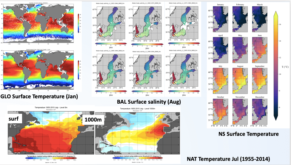
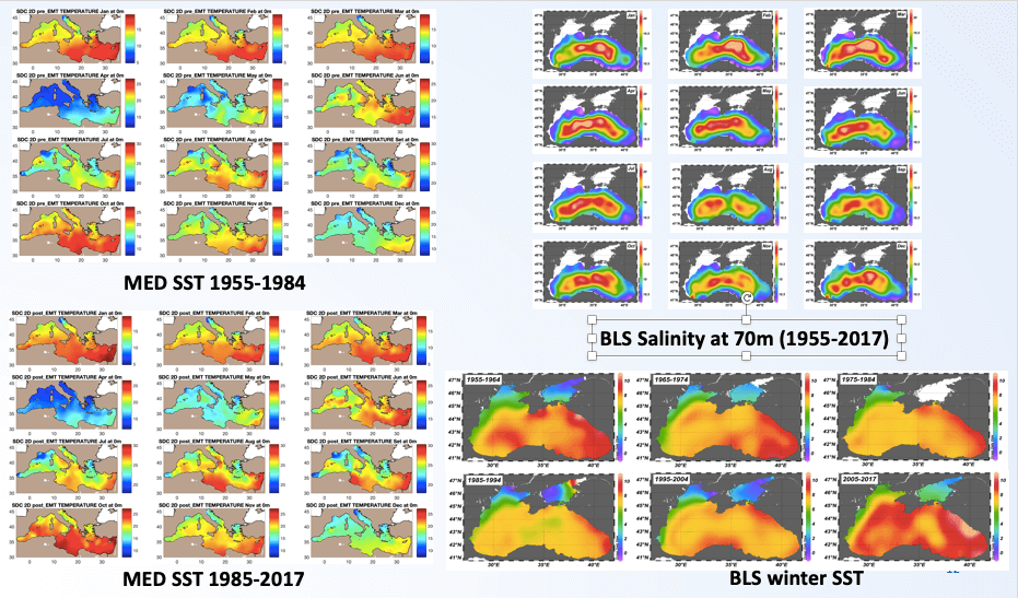
Image: Example plots
of the SDC_CLIM_TS_V1 climatologies.
A
consistency analysis of all SeaDataCloud climatologies versus the World Ocean Atlas 2018 has been performed to demonstrate the differences and
the added value of SeaDataNet data products. Both qualitative and quantitative
analysis suggested a good consistency of SDN products with WOA2018 and
highlighted the added value of regional products compared to the global WOA,
having a lowest spatial resolution. Some issues have been identified by
regional leaders on the quality of their products and have been reported in the
PIDoc section named "Product Usability". Some
examples plots from the PIDocs are given below.
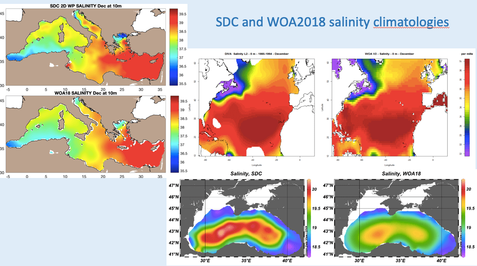
Figure: Example
plots of the consistency analysis performed SDC_CLIM_TS_V1 climatologies.
SDC_CLIM_TS_V1 climatologies have been
produced with a big effort of all partners in the WP11 team. Several gridded
fields at different spatial and/or temporal resolution have been generated for
the first time, all presenting increased vertical resolution. Decadal fields
for regional marginal seas have been created for the first time as well.
The major
achievements have been:
- The uptake of the new DIVAnd software,
the team work jointly to debug and improve it;
- The integration of external sources,
which included the analysis on how much the data sets overlap or
complement each other and the detection of data anomalies and duplicates.
The WP11
team identified possible improvements for the second version of the
climatologies which results are expected by the end of the project. Main issues
to be addressed are:
-
The optimization of the production
chain according to the best solutions developed by the WP11 partners;
- The optimization of the data
integration process;
- The standardization of the duplicate
detection process with external data sources.
A
second version of the aggregated datasets (SDC_DATA_TS_V2) is going to be
released very soon in the SeaDataNet products catalogue, while the new
climatologies (SDC_CLIM_TS_V2) will become available by the end of the project.
In 2013, the IODE Programme of
IOC/UNESCO at its 23rd Session through the Recommendation IODE-XXII.6 and in
cooperation with the WMO-IOC Joint Technical Commission for Oceanography and
Marine Meteorology (JCOMM) established the "Ocean Data Standards and Best
Practices" (ODSBP) Project.
The aim of the project was to achieve broad agreement and commitment to adopt a
number of standards and best practices related to ocean data management and
exchange and to facilitate interoperability. The ODSBP Project was the
continuation of the "Ocean Data Standards" (ODS) Pilot Project, also
established and implemented jointly between IODE and JCOMM. The ODSBP Project
actually extended the activities of its predecessor to include dissemination
and promotion of "best practices", in addition to "standards". The
proposed standards through a review process, which include experts and
community review, when accepted, are recommended for wide use and are published
in the IOC Manuals and Guides series (see Recommended Standards.
For
the dissemination of the best practices, in 2014, IODE established a document
repository, the "OceanDataPractices" repository
(ODPr)
(Recommendation IODE-XXII.19). The repository contained a wide variety of
"practices" such as manuals and guides related to oceanographic data and
information management. It was aiming to provide a platform for organizations
to work on common standards and avoid duplication, to allow individual
researchers from all around the world to find and follow practices approved by
specialized expert bodies and organizations, and to enable research groups that
wish to start a new research project and want to prepare a data management plan
to search and find existing methodologies and "best practices". The service was
also intended for users to submit their own documents that they wish to share
with the community. ODPr was a joint effort by several participating institutions,
which include ICES, IOC/IODE, JCOMM, SCOR and WMO.
The
communication and use of "best practices" by the marine community is a
challenging process. There are diverse oceanographic data that address multiple
needs and the way these data are being collected, managed, documented and
distributed may be "best" for some users but these specifications may not be
the best solution for others. The need for a FAIR global and sustainable ocean
best practice management was recognized by several national and international
organizations and projects. The EU AtlantOS Project and its Best Practices
Working Group with the support of ODIP the (Ocean Data Interoperability
Platform) Project and the NFS Ocean Observation Research Coordination Network)
developed the Ocean Best Practice System
(OBPS) concept. The long-term objective of the Ocean Best Practices System
(OBPS) is to provide the ocean research, observing and application communities
with a mechanism to discover, review, agree upon, adopt and support the widest
possible dissemination of ocean best practices. The existing IOC/UNESCO IODE
"OceanDataPractices" repository (ODPr) was identified as a permanent,
sustainable repository and in 2017 its name changed to "OceanBestPractices" repository to reflect the broader spectrum of "all ocean-related" best practices. The new
System development was centered around this repository that is addressing the
best practices management challenges and it is today one of its elements. In
2019, the OBPS was adopted by the IOC as an international project co-sponsored
by the Global Ocean Observing System (GOOS) and the International Ocean Data
and Information Exchange (IODE). The new System includes the following
elements: 1) a permanent repository, the "OceanBestPracticesSystem Repository" (OBPS-R) that
hosted by IODE offering the scientific community a platform to publish their
ocean-related best practices and find practices of others using innovative
search and access technology, 2) a peer review Research Topic Journal in Frontiers in Marine
Science,
3) web-based and in-person Training and Capacity Building capability based on
the IODE OceanTeacher Global Academy, 4) community outreach and engagement
activities to help users integrate OBPS into their routine work.
SeaDataNet contributions:
SeaDataNet is actively contributing
since the early steps of the initiative and international activities for the
development of "standards" and "best practices". In 2014, four SeaDataNet
standards proposals were submitted to the ODSBP Project:
-
SeaDataNet Cruise
Summary Report (CSR) Data Model proposal
-
SeaDataNet Cruise
Summary Report (CSR) XML Encoding proposal
-
SeaDataNet Common
Data Index (CDI) Data Model proposal
-
SeaDataNet Common
Data Index (CDI) XML Encoding proposal
The
scope of the proposals was to acknowledge the SeaDataNet CDI and the Cruise
Summary Reports (CSR) metadata profiles as standard metadata models for the
documentation of Marine & Oceanographic Datasets and Cruise Reports as well
as their XML encoding as the reference XML implementation. In particular, the
proposals were aiming to promote CDI&CSR as regional (i.e. European)
standards.
In 2015, two joint proposals by
SeaDataNet and the ODIP projects were also submitted to the IODE Standards
Process:
-
SeaDataNet
Controlled Vocabularies, and
-
SeaDataNet NetCDF
(CF) data format,
aiming to acknowledge SeaDataNet
Controlled Vocabularies and NetCDF (CF) as standards used in metadata and data
formats descriptions and as data transport model for processing and sharing
Marine and Oceanographic Datasets and promote them as regional (i.e. European)
standards.
The controlled vocabularies
have been adopted and published as a recommended standard and in the IOC Manual and Guides No. 54
Volume
and at the Ocean
Data Standards site.
The review for the CDI, CSR metadata models and XML schema following the
expert comments has been finalized by the developers of the proposals including
the updating of the technical reference documentation. The next step of the
process is the community review.
As the NetCDF (CF) data format
elements were intended for a "regional" rather than a global standard, the
document was submitted as a "best practice" to the "OceanBestPracticesSystem
Repository" (OBPS-R). In 2019, SeaDataNet submitted an additional ten documents
to the repository (including its standards) describing its data management
manuals and protocols and its data and metadata format specifications:
-
Flow Cytometry
data: format and examples of SeaDataNet ODV data and CDI xml metadata files.
-
Guidelines and
forms for gathering marine litter data. [Updated version: 26/03/2019].
-
Ingesting,
validating, long-term storage and access of Flow Cytometer data.
-
Ocean Data
Standards, Vol.4: SeaDataNet Controlled Vocabularies for describing Marine and
Oceanographic Datasets - A joint Proposal by SeaDataNet and ODIP projects.
-
Proposal for
gathering and managing data sets on marine micro-litter on a European scale.
[Updated version: 07/06/2019].
-
Proposal for
gathering and managing data sets on marine micro-litter on a European scale.
[Updated version: 19/04/2019] [Superseded by DOI:
http://dx.doi.org/10.25607/OBP-495].
-
SeaDataNet Cruise
Summary Report (CSR) metadata profile of ISO 19115-2 - XML encoding, Version
4.0.0.
-
SeaDataNet Cruise
Summary Report (CSR) metadata profile, Version 4.0.0.
-
SeaDataNet
metadata profile of ISO 19115, Version 11.0.0.
-
SeaDataNet
metadata profile of ISO 19115-XML encoding, Version 11.0.0.
-
SeaDataNet NetCDF
format definition. Version 1.21.
The SeaDataNet community "best practices" can
be found at the following website address.
When dealing with (in-situ) observation data, there is a very large
amount of different sensor data encodings, data models as well as interfaces.
This heterogeneity makes the integration of sensor data a very cumbersome task.
For example, without a common standardised approach, it would be necessary to
customise each application that shall consume sensor data to the individual
data formats and interfaces of all sensing devices that will deliver data.
To address this issue, the Open Geospatial Consortium (OGC), an
international de-facto standardisation organisation in the field of spatial
information infrastructures, has developed the Sensor Web Enablement (SWE) framework of standards.
The OGC SWE architecture comprises several specifications facilitating the
sharing of observation data and metadata via the Web. Important building blocks
are standards for observation data models (Observations and Measurements,
O&M), for the corresponding metadata about measurement processes (Sensor
Model Language, SensorML), and interfaces for providing sensor-related
functionality (e.g. data access) via the World Wide Web (Sensor Observation
Service, SOS).

Image: Left: no standards used, requiring
individual integrating of all data sources; Right: reducing the integration efforts by using
SWE standards, common
interfaces and encodings
SeaDataNet strives for a common standardised
approach for describing and giving discovery and access to marine data from
different marine disciplines. Next to delayed mode data sets by means of the
CDI data discovery and access service, standardising efforts are also directed
towards (near) real-time data streams as collected by operational sensors and
platforms. For this application, the SeaDataCloud project has built upon these SWE standards to support the interoperable
sharing of (near) real-time observation data streams. A
SeaDataCloud team, led by partner 52°North, has developed the open source SeaDataNet SWE
Toolkit which comprises the following components:
-
SWE Ingestion Service: this component supports sensor operators to receive and ingest marine observation data from platforms and sensors into a local storage database.
From there (selected) data can be published as streams of (near) real-time observation data by means of
SOS servers. As first step
after installing the Ingestion service, the structure of the data stream has to be described
in the local database, specifying platforms and sensors with SWE metadata
profiles, supported by SeaDataNet SWE vocabularies, and using the 52°North SMLE editor;
- SWE Viewing Services: This component, which is based on the
52°North Helgoland Sensor Web Viewer, is an application for exploring and
visualising the data streams as
retrieved through the SOS services. The viewer supports different types of observation data. It is capable
to visualise data measured along trajectories (e.g. by research vessels)
as well as profile data, besides time series data showing the historic
variations of one or more parameters at fixed locations (e.g. fixed buoys
and sensor stations).
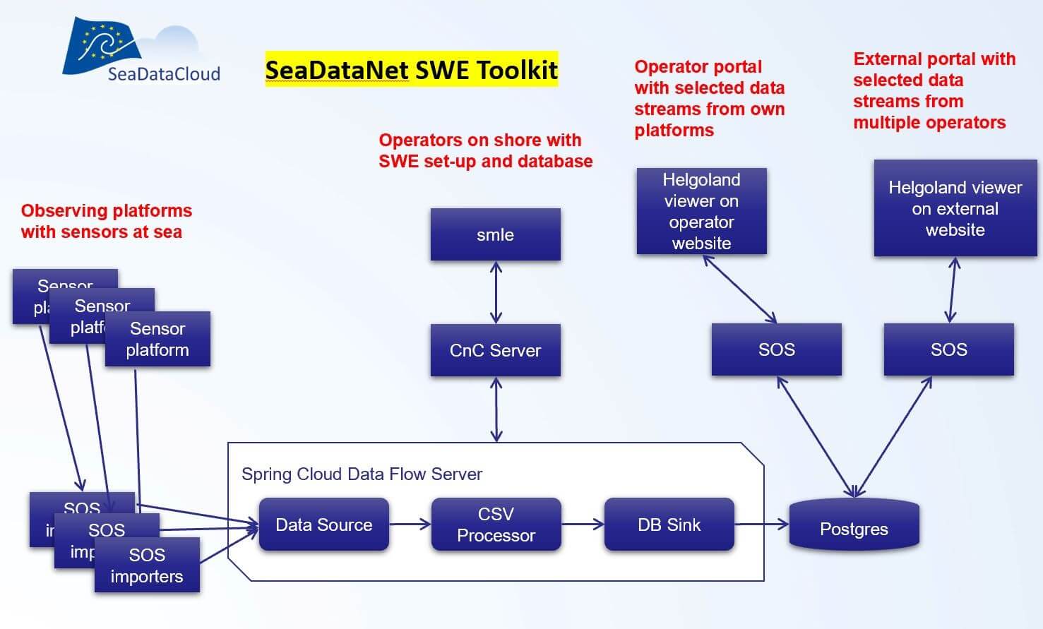
Image: Components of SeaDataNet SWE toolkit deployed in a possible
configuration
At the SeaDataNet
portal homepage a link is given to an SWE demonstrator
of the deployed SeaDataNet SWE Toolkit.
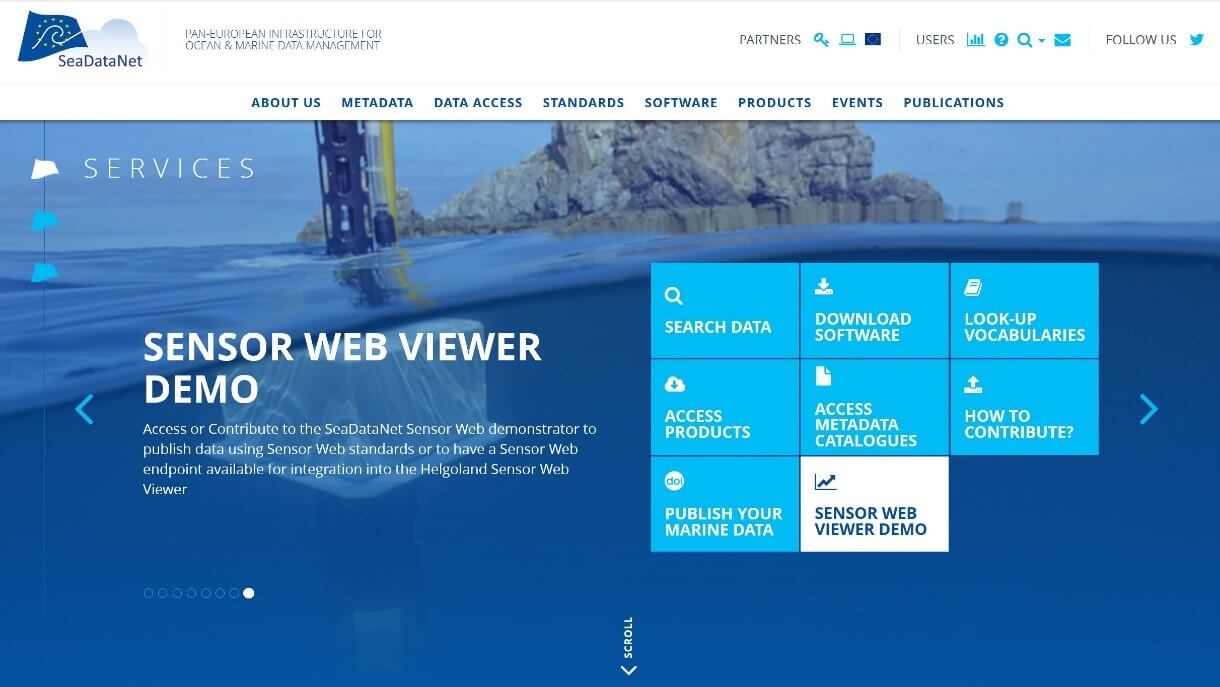
Image: Sensor Web Viewer demo at the SeaDataNet home page
All of the
software in the SeaDataNet SWE Toolkit is published as open source software. To
assist uptake by operators of observing platforms, the Demonstrator also
includes a web page where all relevant documentation and
GitHub resources can be found.
SeaDataNet has developed and maintains a set of tools to
be used by each data centre and freely available from the SeaDataNet
portal. It includes documentation and common
software tools for metadata and data, statistical analysis and grid
interpolation and a versatile software package for data analysis, QA-QC and
presentation. As part of the SeaDataCloud project upgrades are undertaken
taking into account new requirements. The following software versions are
current:
MIKADO,
developed by
IFREMER, is used to generate the XML metadata entries for CDI, CSR, EDMED,
EDMERP and EDIOS SeaDataNet catalogues. The latest version (3.6.2) has been
released in May 2020 with major updates: the CDI ISO 19139 format has been updated
to v12.2.0 for INSPIRE compliance and horizontal datum is now mandatory (var03);
CSR ISO 19139 formats are updated to v5.2.1 for INSPIRE compliance. Protocol
changes from http to https for BODC webservices, SeaDataNet schemas, URN
resolver. CDI and CSR publications are now free links and allow to link e.g. by
DOIs.
NEMO,
developed by
IFREMER, enables conversion of ASCII files of vertical profiles, time series or
trajectories to SeaDataNet format files which can be either text files at Ocean
Data View (ODV) and MedAtlas formats or binary files at NetCDF format. The
latest version (1.7.0) has been released in April 2020 with several bug fixes
and including support for additional formats specifically designed for
Biological, Microlitter and Flow cytometry data. Note that NEMO 1.7.0 and further versions generate files
which can only be managed with RM version >= 1.0.45.
EndsAndBends, developed by IFREMER, is used to generate spatial objects
from raw navigation (ship routes). Typical navigation log files record more
than one location / 10 seconds (ex: GPS outputs) and the Size of these
navigation log files are not practical to be managed or visualized using
standard GIS software or services (WMS, WFS and GML). EndsAndBends enables a
sub-setting of the navigation files, keeping the same geographical shape of the
vessel route and reducing significantly the number of geographical locations to
preserve response time. The latest version of EndsAndBends (2.1.0) has been
released on April 2014; since then no new version has been developed.
OCTOPUS,
developed by
IFREMER, is a SeaDataNet format conversion software and also a format checker
for SeaDataNet ODV, netCDF and MedAtlas files. The latest version (1.5.3.0) has
been released in April 2020 with several bug fixes and additional
functionality: Update URLs for CDIs, CSRs and NERC vocabularies; allow DPSF P09
parameter as depth below sea surface in MedAtlas files (e.g. core data); allow
exception for ODV files with empty vertical reference (e.g. navigation,
contaminants in biota files); conversion MGD to ODV: Change the order of the
depth parameter. All data providers are strongly advised to use OCTOPUS to
check their ODV, netCDF and MedAtlas files before initiating submissions in
order to stick carefully to the agreed formats and rules. OCTOPUS includes
already more than 500 checks. When using this version of Octopus, also the
latest MIKADO versions should be used. Files
generated with OCTOPUS 1.5.3 and further
versions are only compatible with Replication Manager >= 1.0.45.
Replication Manager (RM), developed by IFREMER, handles the
replication of the local data sets managed in a SeaDataNet data centre into the
central cloud. The most recent version of the replication manager (1.0.45) has
been released in April 2020 for the connection of all data centres. The
Replication Manager is a web application which allows data providers to submit
new and updated CDI files to the new CDI import manager at MARIS and at the
same time to publish the corresponding unrestricted data files in the cloud for
user downloading. The restricted data files are kept locally, in a specific
directory, for authorised downloading. In the latest release several fixes have
been made for improving the import and the retrieval of restricted data
requests. All data providers are strongly advised to upgrade to this latest
version for their connections to the CDI service and in dialogue with cdi-support@maris.nl.
Ocean
Data View (ODV), developed by
AWI, provides interactive exploration, analysis and visualization of
oceanographic and other geo-referenced profile or sequence data. It is
available for all major computer platforms and currently has more than 70,000 registered users. ODV has a very rich set of interactive
capabilities and supports a very wide range of plot types. This makes ODV ideal
for visual and automated quality control. The latest release is Version 5.3.0,
released in June 2020. The ODV software is also being used for producing generic SeaDataNet data products - see the article
on SeaDataNet data products. Moreover,
an online version webODV has been developed in the framework of the
development of the SeaDataNet Virtual Research Environment (VRE) - see the
separate article on the VRE.
The Data-Interpolating
Variational Analysis (DIVA) tool, developed by ULg, allows to spatially interpolate (or analyse) observations on a regular
grid in an optimal way. As a part of SeaDataNet, the DIVA method has been
integrated into ODV. Features supported by the
ODV/DIVA integration include proper treatment of domain separation due to land
masses and undersea ridges or seamounts and the realistic estimation of water
mass properties on both sides of the divides. This is important in areas, such
as the Kattegat, with many islands separated by narrow channels. An online version of DIVA has been developed in the framework of the
SeaDataNet Virtual Research Environment (VRE) - see the separate article on the
VRE.
All tools are freely made available
for downloading through the SeaDataNet portal together with manuals for
installation, configuration and use.
The
SeaDataNet infrastructure comprises a network of interconnected data centres
that perform marine data management at national and local levels and that
together make their information and data resources discoverable and accessible
in a harmonized way. The SeaDataNet directory
services provide overviews of marine organisations in Europe, and
their engagement in marine research projects, managing large datasets, and data
acquisition by research vessels and monitoring programmes for the European seas
and global oceans:
- European
Directory of Marine Organisations (EDMO) (> 4.250 entries)
- European
Directory of Marine Environmental Data (EDMED) (> 4.200 entries)
- European
Directory of Marine Environmental Research Projects (EDMERP) (> 3.200
entries)
- European
Directory of Cruise Summary Reports (CSR) (> 58.300 entries)
- European
Directory of the Ocean Observing Systems (EDIOS) (> 350 programmes
and > 16.500 series entries)
- Common
Data Index Data Discovery and Access service (CDI) (>2.39 million
entries)
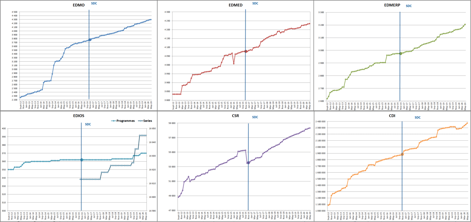
Image:
the monthly progress of each of the directories since September 2012.
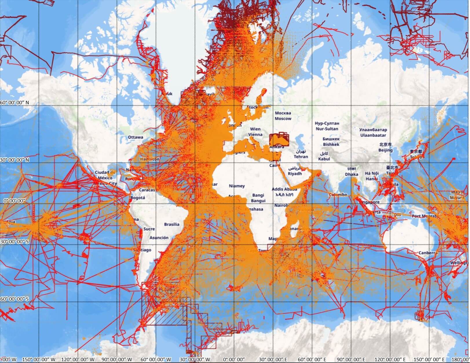
Image:
the coverage of the CDI data service with > 2.39 million entries from 110
data centres and > 750 data originators.
Users can
follow this monthly progress at
the SeaDataNet portal.
This newsletter contains many acronyms which are
described in the following list:
API: Application Programming Interface
AtlantOS:
Optimising and Enhancing the Integrated Atlantic Ocean Observing Systems, an
EU/H2020 Project
CDI:
Common Data Index
CF: Climate and Forecast
CMEMS: Copernicus Marine Environmental Monitoring Service
CSR: Cruise Summary Reports
CSV: Comma Separated Values
CS-W: Catalogue Service for the Web
DIVA: Data-Interpolating Variational Analysis software
DOI: Digital Object Identifier
DTM: Digital Terrain Model
EDIOS: European Directory of Oceanographic Observing Systems
EDMED: European Directory of Marine Environmental Data
EDMERP: European Directory of Marine Environmental Research Projects
EDMO: European Directory of Marine Organisations
EMODnet: European Marine Observation and Data Network
EOSC: European Open Science Cloud
EuroGOOS: European Global Ocean Observing System
FAIR: Findable, Accessible, Interoperable, and Reusable
GEBCO: General Bathymetric Chart of the Oceans
GEOSS: Global Earth Observation System of Systems
GOOS: Global Ocean Observing System
HFR: High Frequency Radar
HPC: High Performance Computing
ICES: International Council for the Exploration of the Sea
ICT: Information and Communication Technologies
IMDIS: International Conference on Marine Data and Information Systems
IOC: Intergovernmental Oceanographic Commission
IODE: International Oceanographic Data and Information Exchange
JCOMM: Joint Technical Commission for Oceanography and Marine Meteorology (now
Joint WMO-IOC Collaborative Board)
ISO: International Organization for Standardization
JSON: Java Script Object Notation
MSFD: Marine Strategy Framework Directive
NetCDF: Network Common Data Form
NFS: National Science Foundation (USA)
NODC: National Oceanographic Data Centre
NRT: Near Real Time
NVS: NERC Vocabulary Services
OBIS: Ocean Biogeographic Information System
ODIP: Ocean Data Interoperability Platform (EU-FP7 and EU-H2020
Project)
ODV:
Ocean Data View software
ODSBP: Ocean Data Standards and Best Practices project
OGC: Open Geospatial Consortium
QA: Quality Assurance
QC: Quality Control
RDA: Research Data Alliance
RSM: Request Status Manager
RTD: Research and Technological Development
SCOR: Scientific
Committee on Oceanic Research
SDB: Satellite Derived Bathymetry
SDC: SeaDataCloud
SDN: SeaDataNet
UNESCO:
United Nations Educational, Scientific and Cultural Organization
URL:
Universal Resource Locator
VRE: Virtual Research Environment
W3C: World Wide Web Consortium
WCS: Web Coverage Service
WebODV: online version of Ocean Data View software
WFS: Web Feature Service
WMO:
World Meteorological Organization
WMS:
Web Map Service
XML: Extensible Markup Language


