Content:
The SeaDataNet II project is actively operating and further developing a pan-European infrastructure for managing, indexing and providing access to ocean and marine data sets and data products, acquired from research cruises and other observational activities in European marine waters and global oceans. It is undertaken by the National Oceanographic Data Centres (NODCs), and marine information services of major research institutes, from 35 coastal states bordering the European seas, and also includes experts in IT, data publishing, and modelling, as well as international organisations, namely IOC, ICES, and EU-JRC in its network. During many years, SeaDataNet is working closely together with other European RTD projects and initiatives such as EMODnet (European Marine Observation and Data Network – initiated by EU DG MARE in 2009) in the capacity of providing standards, services, data centres and infrastructure for managing marine and oceanographic data, and of providing experience and expertise for joint development of new standards and services. Technical innovations in standards and services enrich the basis of SeaDataNet and are implemented in its infrastructure, where possible. The SeaDataNet infrastructure provides harmonised discovery services and access to ocean and marine environmental data sets managed in distributed data centres, not only for partners in the SeaDataNet II project, but for many more data centres.
SeaDataNet is nowadays one of the EU’s largest marine data infrastructures, with more than 1.8 million of data and represents a model for other platforms dealing with marine data management. The developed standards, tools and services for data and metadata, the controlled vocabularies and the data quality control guidance documents and software have been adopted and adapted in many different EU data management projects.
From the start experts have been involved both in the field of operational oceanography and, later on, in the fields of chemistry, geology, geophysics and biology. This has resulted in a system that meets the users’ needs. And substantial progress has been made in the SeaDataNet infrastructure and the services provided.
Our newsletters are an easy way to report on achievements and current activities, events, conferences, collaborations, and software updates in SeaDataNet; it also gives notice about future opportunities and pespectives. The newsletters are instrumental for new users or potential data providers to get an overview of the infrastructure. On the website http://www.seadatanet.org you can find all necessary information and resources to search and download data or to become a data provider.
This is the last edition of the SeaDataNet newsletter, as planned in the framework of the EU FP7 funded SeaDataNet II project. We are already preparing a proposal for SeaDataNet III as part of HORIZON 2020, while the present SeaDataNet infrastructure services are continued as part of our exploitation agreement and participation in various other projects such as the EMODnet portal projects.
Our aim in this newsletter is to report on the last achievements and our future plans. However we also advise you to read the previous newsletter of 20 September 2015, which complements the topics in this version. Its main topics: SeaDataNet developed standards and tools for the marine domain, new features and developments, and the cooperation with other EU projects: EMODnet Chemistry and Bathymetry (viewing and downloading services).
We hope you will enjoy this newsletter and will be triggered to visit the SeaDataNet portal at http://www.seadatanet.org for a try out of its services and to follow its evolution. We aim to reach as many people as possible so, please, forward it to anyone you know may be interested.
The SeaDataNet II project has been undertaken within the EU FP7 framework from 1 September 2011 till end September 2015 as successor to the earlier SeaDataNet project in EU FP6. The final SeaDataNet II plenary project meeting, organised by IFREMER, took place on 16 and 17 September 2015 in Brest (France), at the IFREMER Centre.The final outcome of the project was presented and a strategy has been proposed for future developments and sustainability. It was attended by 94 participants from 32 countries and included also the members of the international advisory board.
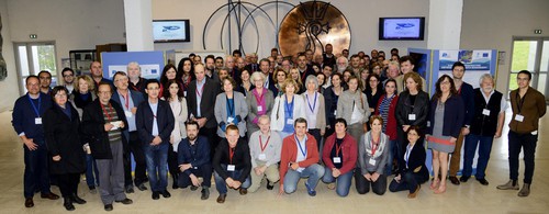
Figure:Participants of the meeting in Brest (image by M. Gouillou, IFREMER)
The meeting started with a welcoming speech and presentation by Antoine Dosdat, director of IFREMER Brest Centre. During the 2-day plenary meeting, the WP leaders and the teams involved described the year’s accomplishments and the overall outcomes of each of the work packages. The project is based on three types of activity: coordination and project management, research and technical development, and transnational access. The SeaDataNet workplan is divided over ten interlinked work packages (WP), of which each falls within one of the three activity types. The plenary meeting also focused on the overall evaluation of the project’s results to be used in the perspective of a new proposal, that will be prepared in the coming months in response to a topic in a new Call in the EU HORIZON 2020 programme which has been formulated with a SeaDataNet successor project in mind. Next to the plenary a final Steering Committee meeting took place for checking the status of deliverables and planning of finalisation of reporting. And also a special meeting of the Technical Task Group together with the Steering Committee was held for preparatory brainstorming on the main goals for the successor project proposal, when thereafter were presented and discussed at the plenary meeting.
A selection of achievements in work packages and future plans are reported in this newsletter.
SeaDataNet manages and ensures the maintaining of the on-line metadata discovery system that allows access to the following resources:
- EDMED (European Directory of Marine Environmental Data) for large data sets,
-
EDMERP (European Directory of Marine Environmental Research Projects)
-
EDMO (European Directory of Marine Organisations)
-
CSR (Cruise Summary Reports)
-
EDIOS (European Directory of Oceanographic Observing Systems)
-
Common Data Index (CDI)
These catalogues allow users to improve their knowledge and to get insight into data activities in the marine domain and about organizations, active in any way in marine data acquisition through monitoring and research. These catalogues are accessible through the SeaDataNet portal with user-friendly interfaces.
SeaDataNet also offers a Common Vocabularies Web Services covering a wide range of ocean and marine disciplines that together with EDMO directory interconnect the metadata directories and makes the different metadata catalogues coherent.
A well-defined and organised model in terms of workflow, governance and maintenance has been developed during SeaDataNet-I and is continually upgraded and improved during SeaDataNet II. This model is shown on the diagram below:
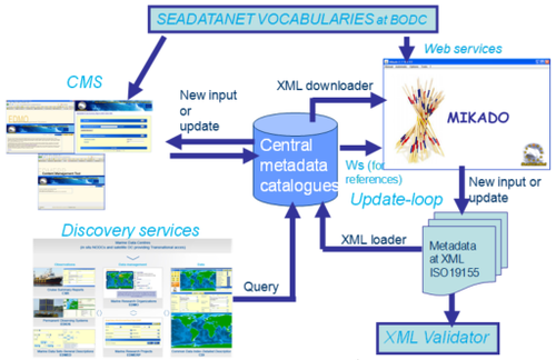
Figure: General maintenance worflow and available tools
As part of the innovation cycle of SeaDataNet II the following technical upgrades were planned:
-
Adopting INSPIRE compliant ISO-19139 based XML schemas for CDI and CSR
-
Adopting Common Vocabularies Version 2 in all metadata directories (CDI, CSR, EDMED, EDMERP, EDIOS) and data formats (SeaDataNet ODV, SeaDataNet NetCDF, SeaDataNet MEDATLAS)
-
Adopting a more effective transfer of updated and new metadata entries for CDI and CSR by applying OGC CS-W harvesting between central portals and distributed data centres
The first 2 actions were implemented and finalised earlier. The remaining action for introducing harvesting of CSR and CDI by using OGC CS-W services has been implemented in the last project period. After analysis in the Technical Task Group it had been decided to make use of GeoNetWork in the configuration as illustrated below:
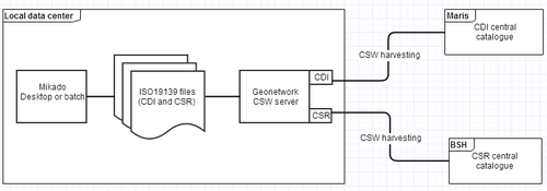
Figure: CS-W configuration using GeoNetWork
SeaDataNet nodes make use of the MIKADO XML editor to generate their CSR and CDI XML entries in ISO 19139. The SeaDataNet nodes may install and configure the Open Source GeoNetWork package to set-up a CS-W node to publish their metadata. For this purpose IFREMER has configured a dedicated version of GeoNetWork for making CDI and CSR XML files available for harvesting. A guidance document with instructions has been released for data centres as well as central managers where to download the customised GeoNetWork package and how to install and configure this for supporting harvesting exchange of CSR and CDI XML files.
The CDI catalogue, harvesting and ingestion service:
MARIS has developed and implemented the CDI harvesting and ingestion system with a dedicated Content Management System (CMS) which allows data centres to follow and control their CDI submissions from load till production. The harvesting is done by using the GeoNetWork solution both in the central and the distributed nodes. Once harvested the CDI XML entries are taken up by the ingestion process. The system runs in steps through a batch process in which the data provider is asked to interact only a few times for the following checks:
-
to identify XML errors (syntax – semantics) for possible repair in next batch,
-
to identify potential duplicates (against import and production) and undertake action to delete real duplicates from the import database
-
to control the overall phases from CDI import and submission to the production environment (after confirming up-to-date coupling table and new data availability).
MARIS monitors the ingestion processes and also keep on processing CDI files received from data centres in the traditional way by email and possibly FTP.
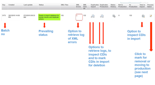
Figure: CDI Ingestion CMS with attributes and functions per batch record
The CDI Harvesting and Ingestion system has successfully been tested by MARIS with 3 data centres: IFREMER (France), BSH (Germany), and IEO (Spain). All three data centres have installed the software client developed by IFREMER for GeoNetwork CSW and configured it for the distribution of CDI XML files. The pilot has helped to test thoroughly the CDI ingestion system and at the same time familiarize the persons at the partner organizations to the alternative work method for updating and adding new CDI entries to the CDI data discovery and access service. The accomplished CDI harvesting and ingestion activities have been documented and are now available also for other SeaDataNet data centres to adopt as alternative to their present submissions.
The CSR catalogue, harvesting and ingestion service:
Cruise Summary Reports (CSR) have a long tradition and they are the first available information on a research cruise after the expedition. The CSR directory is centrally maintained by BSH with CSR XML submissions by SeaDataNet national nodes. The CSR format is based upon the ISO 19115 and 19115-2 (for measurements and samples part) content models. The CSR XML entries are produced with MIKADO and follow the ISO 19139 schema and make optimal use of the SeaDataNet controlled vocabularies and other directories, such as EDMO and EDMERP. Over time the contents of the CSRs has been extended and nowadays also includes linking to trackcharts (image / WMS by means of GML) and station lists.
CSR is also in use for the Research Vessels portal of the Partnership for Observation of the Global Oceans (POGO). EurOcean (Portugal) maintains a global directory of Research Vessels, which are linked by ICES Shipcodes (C17 vocabulary) to CSR. The POGO portal has a focus on ocean-going RVs (length >60 metres) and is managed by SeaDataNet partners (BODC, MARIS and BSH). It gives the RV directory, the CSR directory and a directory of Cruise Programmes (CP).
Previously there were 2 options for the CSR submission:
-
via the SDN online Content Management System
-
via e-mail or FTP adopting the ISO19139 XML schema.
Early 2015 this has been extended with CSR submission via CS-W harvesting. The CSR records in ISO19139 format are retrieved by BSH directly from the connected nodes using the GeoNetWork solution. Initially a test phase with 4 pilot members was undertaken. And since middle of February 2015 CSR harvesting is operational. The Cruise Summary Reports are now harvested weekly from IFREMER, HCMR, IEO and OGS to populate the SDN CSR inventory. CSR CS-W harvesting appears to be a very efficient way to collect and update information on the past and present research cruises.The new and modified records from the connected data centres are regularly and automatically updated at the central CSR portal.
The harvesting takes place in 2 phases:
-
the harvested CSR records are first stored in a temporary entry database where format, vocabulary and quality control checks will be performed. Thereafter the centres will be informed about any format or plausibility issues;
-
The records which passed the QC procedure will be loaded into the CSR Central Inventory. The updated records of existing CSRs will be verified through the unique “local cruise IDs” given by each data centre (collating centre). The new records will be added to the inventory. All new and updated records will be automatically published on the SeaDataNet and POGO Cruise Summary Report portal.
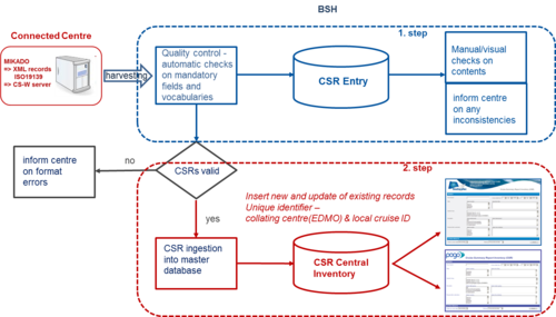
Figure: CSR harvesting and ingestion workflow
Several SeaDataNet partners are involved in the Ocean Data Interoperability Platform (ODIP) project, which will be described in another article in more detail. As part of ODIP prototypes of interoperability solutions are developed and evaluated. One of these prototypes concerns the “Cruise Summary Report” – ODIP Prototype 2: Establishing interoperability between cruise summary reporting systems in Europe, the USA and Australia. The aim is to harvest CSRs from the regional GeoNetwork nodes of the 3 continents into the POGO global catalogue, so that integrated search on CSRs is possible.
The Rolling Deck to Repository (R2R) project in the USA aims at providing uniform stewardship of routinely-collected environmental sensor data from the US academic research fleet. As of October 2015 it covers 5749 Cruise IDs from 38 RVs. In Australia RV voyage metadata in Australia is stored in the CSIRO Marine and Atmospheric Research metadata system, MarLIN, along with metadata on datasets from the Marine National Facility (MNF) and other sources. It gives per RV the survey details, voyage plan, voyage track and voyage data.
For the purpose of the ODIP Prototype 2, both R2R (USA) and NMF (Australia) have adopted the SeaDataNet Cruise Summary Report (CSR) metadata profile and schema. And R2R has deployed the SeaDataNet customised GeoNetWork software module. USA and Australian partners have undertaken considerable effort with mapping between their local and SeaDataNet vocabularies and the further population of these vocabularies with additional terms in case of missing terms with support of NERC-BODC as manager of the SeaDataNet vocabularies. Also the EDMO directory for organisations and their addresses has been extended with > 400 entries for USA institutes which are relevant in the context of the R2R system and with > 228 entries for Australian institutes. Accounts has been set-up in the EDMO CMS system for USA and Australian colleagues to maintain their national collection. And MARIS has upgraded the EDMO user interface to make also USA and Australian entries accessible.
R2R (USA) has already contributed 130 CSR records of US research cruises to the CSR directory. NMF (Australia) so far has contributed only one CSR. Through the CSR harmonisation process between ICES and BSH further CSRs from Canada and other countries will be available on the SeaDataNet as well as on the POGO portal for Cruise Summary Reports.
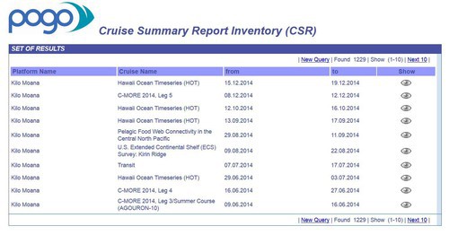
Figure: USA CSR entries in the POGO portal
The R2R team has agreed to continue in the successor ODIP II project with further submissions, striving for a larger population of the POGO portal. For Australia it has been agreed that the Australian partners will also pursue further CSR implementation, also because Australia is well engaged with POGO in its Blue Planet initiative.
The upgraded EDMO directory:
The EDMO (European Directory of Marine Organisations) discovery portal has been updated, also in conjunction with the ODIP developments. The Search page has been somewhat restyled. Important changes have been made in the results page which now gives a matrix of selected organisations and their engagement in any of the activities as described in the SeaDataNet Directories, but also in the Eurofleets Cruise Planning directory, POGO directories and the SIMORC catalogue. The matrix then allows to click directly with a specific query towards these related directories. Also mapping of locations of organisations has become more important.
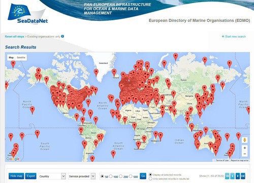
Figure: The new SeaDataNet search interface with map of search results and organisation details
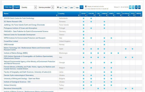
Figure: The new SeaDataNet EDMO search interface with search results in matrix which allows to retrieve entries of the selected organisation in other SeaDataNet and related directories, such as POGO and SIMORC.
Nowadays EDMO gives profiles and addresses of more than 4000 organisations.
Present status of the SeaDataNet directories:
The following image gives a good illustration of the ongoing population of each of these catalogue services.
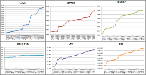
Figure: Population of SeaDataNet catalogue services since September 2011. These statistics for the catalogue services can be followed at : http://www.seadatanet.org/Overview/
Status of CDI Data Discovery and Access service:
A major service is the SeaDataNet CDI Data Discovery and Access service. At present it connects and gives access to marine data sets from more than 100 data centres from 34 countries, riparian to European seas, and nearly 1.8 million data sets for physical oceanography, chemistry, geology, geophysics, bathymetry and biology, originating from more than 550 organisations.
All the data sets are collected in research projects and monitoring programmes and after a process of quality control and formatting, archived in the local databases of the data centres that are connected to the SeaDataNet CDI Data Discovery and Access service. The CDI metadata is based upon the ISO 19115 – 19139 standards and completed by the data centres using common SeaDataNet tools and SeaDataNet controlled vocabularies, where possible. The metadata are kept up-to-date in a central catalogue with user-friendly interfaces. The service also includes a shopping basket mechanism including a transaction tracking service for users to request access to identified data sets, to monitor processing of requests, and to download data sets in standard formats.
This is the effect of the well positioning of the SeaDataNet infrastructure in many other projects funded by the EU as part of the RTD programme and as part of EMODnet. The SeaDataNet standards and CDI infrastructure has been adopted in the following projects: Geo-Seas, Eurofleets 2, JERICO, JERICONEXT, Upgrade Black Sea SCENE, CaspInfo, Micro-B3, CLIPC, CitClops, AtlantOS, CoCoNet, EMODnet Chemistry, EMODnet Bathymetry, EMODnet Geology, EMODnet Physics, and EMODnet Biology.
This way more data centres are adopting the SeaDataNet standards and principles and also populating the CDI service with extra data sets. The CDI service gives access to circa 1.8 million data sets.These data sets are managed by more than 100 connected data centres and originate from more than 500 institutes in Europe. This is illustrated in the following two figures.
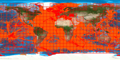
Figure: CDI coverage end November 2015
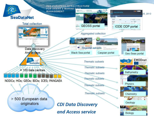
Figure: Illustration of adoption of CDI service in other projects and portals
The SeaDataNet portal provides a 'single stop shop' for all kinds of users to discover and request access to ocean and marine data sets acquired by European organisations for the European seas and global oceans.
A session of the meeting was dedicated to report the experience of some partners showing how adopting the SeaDataNet data management system, standards and tools has improved the overall data processing efficiency, starting from quality check to data publishing. From the many success stories we highlight the case of the National Institute of Marine Sciences and Technologies “INSTM” of Tunisia.
The Marine Environment Laboratory “LMM” is part of the National Institute of Marine Sciences and Technologies “INSTM” of Tunisia and is a solid SeaDataNet I and II partner. INSTM shows a lot of interest for data management protocols and within the framework of the SeaDataNet II project, has updated its marine data management method. Furthermore INSTM is adopting this data management approach in its new projects. Since January 2015, the Tunisian institute is working with the Mediterranean Oceanology Institute of Marseille (MIO), France on the project entitled Continuous High Resolution Observation of the MEditerranean sea “CHROME” project co-funded by the A*MIDEX foundation and the INSTM. The CHROME project is intended mainly to:
-
Design and implement an innovative Ferrybox multi-parametric system in the Mediterranean Sea and add to the traditional system automation and remote controlled flow cytometry.
-
Characterize and map the major phytoplankton functional groups in the Western Mediterranean open sea.
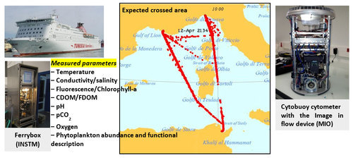
Figure: Map of the ferry's expected route and the sensors that will be put on the ferry (Ferrybox and Cytosense flow cytometer).
INSTM, in charge of the hydrological data, acquires data sets from the Ferrybox onboard the ferry C/F CARTHAGE from the “Compagnie de Navigation Tunisienne” (CTN) that has regular lines between Tunis-Marseille and Tunis-Genoa (see figure). Data acquired from the Ferrybox will be managed according to CORIOLIS protocol. The MIO team, a world leader in high frequency in-situ observation of phytoplankton at the single cell level, is in charge of implementing the flow cytometer (the Cytosense) on board the C/F CARTHAGE.
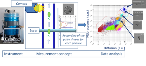
Figure: The Cytobuoy flow cytometer records each particle in the sample, thanks to the hydrodynamical focusing concept
With INSTM support and experience, the MIO is very interested in adopting good practices as used in SeaDataNet: tools and methods. For that purpose the SDN lead team delivered a new version of "NEMO" (July 2015) which fits better with the cytosense dataset (B08). The adoption of the SeaDataNet data management standards required a collaborative effort to expand the existing vocabulary terms between the SeaDataNet and the flow cytometry communities. The Flow cytometry standard dataset will have the following workflow.
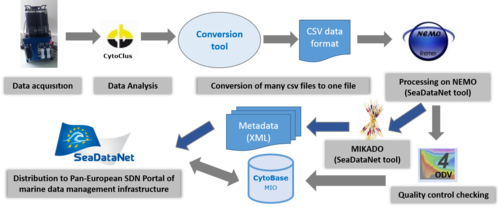
Figure: Data management workflow for the cytometry data
SeaDataNet makes use of Authentication, Authorisation and Accounting (AAA) services for a number of its services, such as for the submission of requests for data sets and downloading of requested data sets as part of the CDI service shopping mechanism. For SeaDataNet 2 and possible other projects it has been decided to develop and migrate to a new system for registration and authentication of marine datasets users. This system has been called Marine-id. As for the previous system and eduGain federation of identity, CAS is used for authentication management. For user registration the open-source software PWM is used. It provides the required security features for such functions as CAPTCHA and email confirmation. The full Marine-id implementation for user registration and authentication has been deployed in production in April, 2015.
The Marine-id system manages user registration and authentication. Marine-id has also been designed to cooperate with SeaDataNet where registered users are also required to agree with the SeaDataNet license and must receive a role to be used as input for the decision matrix in the CDI shopping mechanism. The actual switch by SeaDataNet from the former system to Marine-id and migration of the existing users has been done in early October 2015.
SeaDataNet has developed and maintains a set of common standards for the marine domain, collaborating with European and international experts within the framework of IOC-IODE, ICES, and ODIP, adopting and adapting ISO and OGC standards, and achieving INSPIRE compliance.
A number of the SeaDataNet standards have been submitted to the Ocean Data Standards and Best Practices Project (ODSBP) of IODE and JCOMM.
The objective of ODSBP is to achieve broad agreement and commitment to adopt a number of standards and best practices related to ocean data management and exchange. This includes the following main tasks:
-
develop and manage a process for the reception, reviewing and recommending of standards and best practices, based upon the process developed by the Ocean Data Standards Pilot Project;
-
actively liaise with all relevant communities, programmes and projects such as Ocean Data Portal, ETDMP Metadata Task Team, SeaDataNet Technical Task Team, GE-BICH, GE-MIM, SG-OBIS, GTSPP, ICSU WDS, GEO/GEOSS, ICES;
-
promote and monitor the usage of recommended standards and practices in the relevant communities, including those mentioned under (ii);
-
regularly review and revise recommended standards and best practices based upon feedback from the relevant communities, including those mentioned under (ii);
-
maintain an online catalogue of best practices, enabling easy discovery and downloading of these documents by users (e.g. JCOMM Catalogue of practices and standards).
The ODSBP project is managed by the IODE Steering Group for the Ocean Data Standards and Best Practices Project (SG-ODSBP). This is composed of (i) the former members of the JCOMM/IODE ETDMP Task Team for the Ocean Data Standards Pilot Project, (ii) experts from relevant JCOMM bodies, and representatives of IODE NODCs with a special interest in data standards. In addition representatives of major international oceanographic data management projects may be invited as relevant to the agenda.
SeaDataNet together with ODIP has submitted the following standards to ODSBP:
-
the ISO 19115 – 19139 standard based formats and schemas for describing metadata on data sets (CDI = Common Data Index) and research cruises (CSR = Cruise Summary Reports). These standards consist of marine metadata profiles, schema’s, and schematron rules, which have been fully documented and can be retrieved from the SeaDataNet portal.
- the SeaDataNet Controlled vocabularies for the marine domain (> 160.000 terms and > 60 lists), with international governance, user interfaces and web services. Use of common vocabularies in all metadatabases and data formats is an important prerequisite towards consistency and interoperability. The SeaDataNet vocabularies have been developed and are maintained by NERC-BODC. The present version 2.0 (NVS2.0) follows the SKOS specification for encoding data dictionaries and taxonomies served. See the SeaDataNet portal for more information and access to the services.
-
the SeaDataNet NetCDF with CF compliance for profiles, time series and trajectories. As part of the SeaDataNet services, data sets are accessible via download services. Delivery of data to users requires common data transport formats, which interact with other SeaDataNet standards such as the Vocabularies and SeaDataNet Quality Flag Scale and with SeaDataNet analysis & presentation tools (ODV and DIVA). One of the supported formats is SeaDataNet NetCDF (CF). See the SeaDataNet portal for more information and documentation.
The aim of the submission is to have an official recognition for the developed standards and to achieve long-term preservation. Also it is aimed at distributing best practices to other regions.
SeaDataNet has prepared and publishes basic regional data products consisting of aggregated sets of observational data and interpolated maps for specific parameters, Temperature and Salinity. The SeaDataNet products are divided over 6 regional sea areas: Mediterranean, Black Sea, North Atlantic Ocean, North Seas, Baltic and Artic and are derived from the data sets as present in the SeaDataNet infrastructure. The products developed are regional (temperature and salinity) climatologies and aggregated dataset collections.
Harvesting of data sets:
The SeaDataNet CDI Data Discovery and Access service with its network of distributed data centres provides an integrated and harmonised overview and access to ocean and marine observation data sets as managed by connected SeaDataNet data centres. The basic data sets (Temperature and Salinity observations) have been derived from the SeaDataNet CDI service. The required search and retrieval initially have been performed partly manually, but in later stages successfully use was made of the CDI robot harvesting system. This system supports automatic discovery and harvesting of metadata and data sets, and an online SeaDataNet Buffer Content Management System (CMS), which allows to configure specific group profiles (specify group, involved users, motivation, query criteria). The Buffer CMS works together with the upgraded Request Status Manager (RSM) service, an existing component of the CDI shopping mechanism, to perform and administer robot shopping transactions and to store the harvested data sets in central buffers. This also includes maintenance, whereby new and updated CDI entries are identified and used to trigger additional harvesting for the central data buffers.
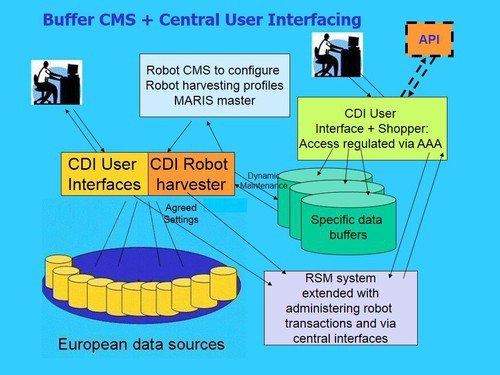
Figure: The SeaDataNet robot harvesting system and central buffers
The Central shopping mechanism works on the data Buffers and can deliver (in delayed mode) large data sets which are divided over downloadable zip files with maximum 10.000 data sets each; all shopping transactions are administered in new section of the RSM. Note: the central buffers are exclusive for specific applications and access is secured via AAA service only for authorised users. These buffers do not replace the distributed CDI infrastructure and its shopping process for regular users.
Validation and aggregation of regional data collections:
The SeaDataNet Ocean Data View (ODV) software has been used by regional coordinators to quality control and harmonise the gathered data collections for generating regional data products. Quality control is a key issue when merging heterogeneous data coming from many different sources. For this reason, a Quality Control Strategy (QCS) was defined and implemented, consisting in the steps illustrated below:
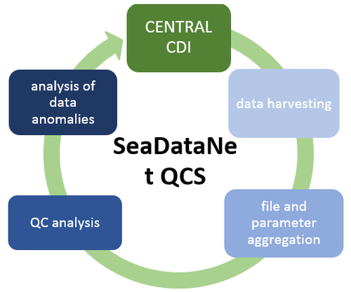
Figure: Schema of the Quality Check Strategy implemented in synergy with NODCs
Collaboration took place with the MyOcean II and “MyOcean Follow On” projects in order to share the SeaDataNet’s recent data (1990-2012) also for MyOcean and for a joint QA-QC. The ODV software has been used to check the quality of the aggregated datasets that are distributed as ODV collection files. They have been divided into 2 parts: (1) all the SeaDataNet licensed/unrestricted data and (2) all the restricted data on the other hand. Both parts have been used for the climatology computation with DIVA software and these maps are made available for browsing and downloading at the SeaDataNet portal, while aggregated data collections are published only for the licensed/unrestricted data.
During the QCS process some issues or anomalies were encountered in the temperature and salinity data and efforts were undertaken by the data providers for improving both the quality of the data sets and their metadata as the initial data products. Two SDN QCS cycles have been completed and resulted in two versions of the aggregated dataset collections. In general, the V2 data collections contain more data than the V1.1 version, with the exception of the Black Sea with an overall reduction of the order of the 5%, due to the removal of duplicates and data from the CDI due to the Crimea crisis. The overall quality of V2 datasets ranges from very good and good, indicating that the QC strategy implemented was successful and that most of the data providers made the corrections in the central CDI catalogue, as suggested by the regional coordinators after the generation of the aggregated dataset V1.1.
SeaDataNet regional products are of 2 different types: (1) the aggregated datasets of temperature and salinity which are ODV collections of all SeaDataNet measurements of temperature and salinity by sea basins and (2) the temperature and salinity climatologies which are regional gridded field products based on the aggregated datasets.
Climatologies:
SeaDataNet gridded climatologies are based on the aggregated data collections. The preparation of the products has also improved the quality, the consistency and the overall coherence of the data made available by SeaDataNet. They have been computed using DIVA software. DIVA software tool (Data-Interpolating Variational Analysis), developed by the University of Liege, allows to spatially interpolate (or analyse) observations on a regular grid in an optimal way. The analysis is performed on a finite element grid allowing for a spatial variable resolution and a good representation of the coastline and isobaths. As some areas covered in the European seas have complex coastlines, the finite-element grid of DIVA will be able to adequately resolve those.
Regional Climatologies (RCs) presented the first results on regional climatologies in April 2015. At the final meeting all RCs presented their latest climatologies and their results on the consistency analysis. We underline that there are small differences in the obtained results and also in RMSE and BIAS values that are currently unexplained.
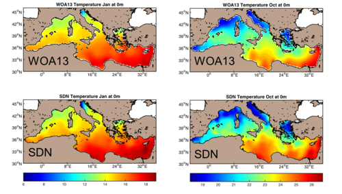
Figure: Monthly surface temperature of the Mediterranean Sea in January (bottom left) and October (bottom right) compared to the corresponding WOA2013 field (top panels)
This figure gives some examples of temperature monthly climatologies of the Mediterranean Sea compared to the corresponding fields of WOA2013. The Mediterranean Sea climatology has been validated considering the WOA13 temperature (Locarnini et al. 2013) and salinity (Zweng et al. 2013) climatologies as a reference.
Products catalogue, viewing and download services
The regional climatologies and the aggregated data collections have been described with metadata and can be discovered in the SeaDataNet Sextant products catalogue, operated by IFREMER, which can be found at: http://sextant.ifremer.fr/en/web/seadatanet/
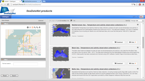
Figure: the Sextant data products catalogue service
The OceanBrowser Viewing service, developed and maintained by University of Liege (Ulg), provides access to the DIVA interpolated maps. Output images are available as horizontal sections and vertical sections. The latter can be selected by drawing an appropriate transect. ULg together with IFREMER have integrated the Sextant data products catalogue with the OceanBrowser. This now gives users the option to select SeaDataNet data products in the Sextant catalogue and then to visualise and browse those in the OceanBrowser. Alternatively users can visualise data products in the OceanBrowser and then to look up their description from the Sextant Catalogue. The visualisation of the T&S Climatology maps in the OceanBrowser service is illustrated below for the Atlantic Ocean.
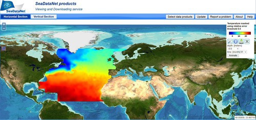
Figure: OceanBrowser for viewing the climatology map for the Atlantic
In addition a new service has been added by adaption of Oceanotron for giving access and visualization services to the SeaDataNet data collections. Oceanotron has been initiated by IFREMER in the framework of the MyOcean project and it has been further developed as part of SeaDataNet II and the MyOcean projects. It gives advanced services on top of in-situ data collections.
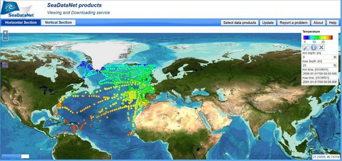
Figure: Visualisation of T&S data collection for Atlantic via Oceanotron and OceanBrowser
The visualisation and interactivity of the regional T&S data collections is arranged by using Oceanotron. In practice it works as follows :
- The regional T&S data collections have been prepared with the ODV (Ocean Data View) software and are managed as ODV binary collections;
- The ODV software has been equipped by AWI with an API to allow reading the ODV binary collections;
- A plug-in has been developed by Ifremer to enable Oceanotron to make use of the ODV API and this way to interact with the data collections;
- Furthermore WMS services have been implemented as part of Oceanotron using ncWMS from the University of Reading to enable interacting and sharing results of interactions of Oceanotron with the data collections ;
- The Oceanotron WMS service has been integrated into the OceanBrowser.
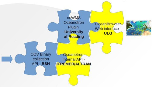
Figure: Integration of various components to visualize the regional data collections
One of the major objective in SeaDataNet is to provide users common means for analysing and presenting data and data products. Therefore common software tools are being developed and freely made available to data centres and end users. SeaDataNet has adopted the freely available Ocean Data View (ODV) software package as its fundamental data analysis and visualisation software. ODV provides interactive exploration, analysis and visualization of oceanographic and other geo-referenced profile or sequence data. It is available for all major computer platforms and currently has more than 40,000 registered users. ODV has a very rich set of interactive capabilities and supports a very wide range of plot types. This makes ODV ideal for visual and automated quality control.
The ODV 4.7.4 version (October 2015) provides support for the import and aggregation of SDN data files both in SDN spreadsheet as well as the new SDN netCDF (CF) formats. The new 64bit ODV executables allow import of the entire SDN data holdings in a single import step. ODV 4.7.4 now also provides extended metadata support by extracting and storing 56 meta-variables from SDN CDI records. Every station in ODV collections now maintains its own set of history records thereby documenting data provenance information as well as keeping activity logs of all metadata and data modifications made by users. Data usage agreements are now extracted from the import files and presented to the user when opening the imported data for the first time. Acceptance of the usage agreements is required before access to the data is given. Aggregation of variables possibly including unit conversions is implemented on the basis of the SeaDataNet P35 vocabulary and a web-based unit conversion library maintained by partner AWI. The new ODV collection format now allows storage of data error values and info strings, in addition to data values and quality flags. The latest version of ODV as well as the documentation and a full list of changes are available in the Software section: http://www.seadatanet.org/Standards-Software/Software/ODV
Extended Meta Variable Support: the SDN importer extracts the metadata for 56 CDI meta-variables from the imported .csv files. This includes instrument and sensor codes where available as well as references to documents on the Internet. Several of the metadata items are clickable, e.g. more detailed information is displayed in the web-browser windows when clicked. The per-station history remembers the full path of the SDN/ODV data file from which the station originates. This features greatly facilitates tracing problems back to original files.
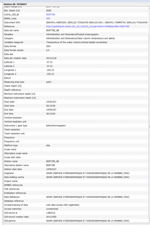
Figure: Extra metadata variables in SDN data collections. Values in blue color are clickable items
This results in metadata enriched data files and data collections which is very useful for further use and analyses.
P35 Data Variable Aggregation: Data collections that have been produced via Import > SDN Formats can be further processed by automatically aggregating variables and writing the results to a new collection via Export > Station Data > SDN Aggregated ODV Collection. Aggregation of variables is performed to combine multiple individual variables for a given quantity into a single variable for easy scientific usage. For instance, there are more than 15 parameter codes for seawater dissolved oxygen in common use in the SDN data files. From a usage perspective this is unfortunate, and an aggregation into a single oxygen variable is desired. The P35 vocabulary addresses this need and enables variable aggregation in an automatic way by defining lists of contributing individual parameters for many important oceanographic variables. The image below shows the entry for Water body dissolved oxygen.
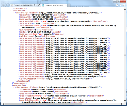
Figure: P35 entry for Water body dissolved oxygen
Before performing the aggregation ODV first downloads the latest version of the P35 vocabulary from http://vocab.nerc.ac.uk/collection/P35/current/. P35 defines numerous aggregated variables by specifying lists of contributing variables as well as the preferred units of the aggregated variable. ODV also downloads the latest version of the list of unit conversions from the ODV website. If not connected to the Internet ODV uses the most recent versions of these files available on the system. Required unit conversions are applied automatically during aggregation. P35 aggregated variables use the SEADATANET quality flag scheme.
The order of variables in the output collection is as follows:
-
the primary variable of the source collection,
-
the P35 aggregated variables for which contributing variables are found in the source collection,
-
the variables in the source collection not contributing to any P35 aggregated variable.
An example of the resulting list of variables is shown below.
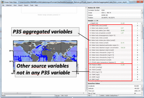
Figure: the list of variables after P35 variable aggregation
The value and quality flag of a P35 aggregated variable is obtained as follows:
-
if only one contributing variable contains data: use the value and quality flag unchanged,
-
if more than one contributing variable contain data: use the median of all contributing values; map all quality flags to ODV scheme, take maximum of mapped values and then map back to the SEADATANET scheme.
The user can view the list of unknown conversions (if any) and the list of constructed P35 aggregated variables and their contributing input variables by opening the output collection and using the Collection > Browse Info File option. If a contributing variable requires a yet unknown conversion, this input variable is ignored and its data are not used in the aggregation. If users encounter missing conversions they can request inclusion of the new conversion in the ODV conversion database by contacting partner AWI. Once the new conversion is entered into the web-based unit conversion library the user just re-runs the P35 aggregation step.
The latest version of ODV as well as the documentation and a full list of changes are available in the Software section: http://www.seadatanet.org/Standards-Software/Software/ODV
Europe, the USA, and Australia are making significant progress in facilitating the discovery, access and long term stewardship of ocean and marine data through the development, implementation, population and operation of national, regional or international distributed ocean and marine observing and data management infrastructures such as SeaDataNet, EMODnet, IOOS, R2R, and IMOS. All of these developments are resulting in the development of standards and services implemented and used by their regional communities. The Ocean Data Interoperability Platform (ODIP) project has been supported by the EU FP7 Research Infrastructures programme, National Science Foundation (USA) and Australian government and has been initiated 1st October 2012. Recently the project has been continued as ODIP II for another 3 years with EU HORIZON 2020 funding. ODIP includes all the major organisations engaged in ocean data management in EU, US, and Australia. ODIP is also supported by the IOC-IODE, closely linking this activity with its Ocean Data Portal (ODP) and Ocean Data Standards Best Practices (ODSBP) project. The ODIP platform aims to ease interoperability between the regional marine data management infrastructures. Therefore it facilitates an organised dialogue between the key infrastructure representatives by means of publishing best practice, organising a series of international workshops and fostering the development of common standards and interoperability solutions. These are evaluated and tested by means of prototype projects. As part of the first ODIP project three prototype projects have been undertaken:
-
establishing interoperability between the regional EU, USA and Australia data discovery and access services (SeaDataNet CDI, US NODC, and IMOS MCP) and contributing to the global GEOSS and IODE-ODP portals;
-
establishing interoperability between cruise summary reporting systems in Europe, the USA and Australia for routine harvesting of cruise data for delivery via the Partnership for Observation of Global Oceans (POGO) global portal;
-
the establishment of common standards for a Sensor Observation Service (SOS) for selected sensors installed on vessels and in real-time monitoring systems using sensor web enablement (SWE).
These prototypes have recently been finalised within the first ODIP project and the results and related reports can be found at the ODIP website. The successor ODIP II project has started in April 2015 under EU HORIZON 2020 and the consortium has been expanded with additional partners from EU., USA and Australia while the approach with workshops and formulating and developing specific prototypes is continued.
Users of oceanographic data resulting from monitoring stations are generally interested in both the long-term archived time series as well as the near-real time or real time data. This is also requested in dedicated projects such as the new AtlantOS project, which is aiming for an integrated Atlantic Ocean observing system, and EMODnet Physics which aims at providing users an easy portal for discovery and access to physics data from all operational stations, such as buoys, fixed poles, gliders, floaters (ARGO) and other instrumented platforms. In practice, provision of real-time data and delayed-mode data is arranged by different infrastructures. Real-time and near real-time data are managed in a cooperation between the EuroGOOS ROOSs (Regional Operational Oceanography Systems) and the INSTAC (In Situ Thematic Assembly Centre) of the Copernicus Marine Environment Monitoring Service (CMEMS). The present Copernicus INSTAC.CMEMS has been developed in coherence with other components of the pan-European data management landscape following the EuroGOOS recommendation adopted in 2008 by the EuroGOOS Assembly. The INSTAC.CMEMS makes use of standards and vocabularies developed within SeaDataNet and is interoperable both upstream with the observation provider networks and downstream with initiatives including EMODnet Physics.
The physical data sets are also gathered by data centres (in particular NODCs) from organisations operating monitoring stations in their country (both from research and monitoring activities) and after additional QA-QC and processing stored in their databases for long-term archiving. The additional scientific validation and documentation of the data sets is required to make these data sets also fit for purpose of scientific analyses such as generating climatologies, studying climate changes, sea level rise and other topics which require high quality data sets. The data centres populate metadata and data also into the European SeaDataNet infrastructure, which is managed by the NODCs in Europe, and which then provides the basis for making archived physical data available for users and portals such as EMODnet Physics.
EuroGOOS, CMEMS and SeaDataNet work closely together to provide discovery and access to physics data sets in an harmonised way. SeaDataNet also plays an important role in developing standards and protocols that can be adopted for wider implementation. For that purpose SeaDataNet has undertaken activities for extending its traditional data access services as provided on long term archive datasets. This extension aims at facilitating access and especially visualization of the time-series datasets provided in near real time by operational oceanography data providers. For doing this, SeaDataNet has taken benefit of the Sensor Web Enablement (SWE) technologies which are designed and increasingly implemented to provide standard services close to the observatories. Discovery and access to long-term time series is provided by SeaDataNet through its CDI Data Discovery and Access service. For demonstrating support for operational oceanography data sets, it was decided to develop an extension to the CDI service in such a way that users of the SeaDataNet CDI service will have an additional functionality to access and visualize near real-time data from the same monitoring station that also provided the long-term data sets. These long term data sets are normally described in the CDI entries.
This extension has been demonstrated for selected monitoring stations. The demonstrator has been set-up to with data sets resulting from 2 monitoring stations: E2M3A mooring as operated by OGS; EMSO Azores deep sea observatory as operated by Ifremer. The technical architecture is composed of 3 new components and one upgraded and comprises:
- (new) 2 SOS servers deployed at data provider level
- (new) 1 SOS client for time-series visualization
- (upgraded) the CDI data access portal and catalogue providing observation description and federating the links to the pre-existing download access points and the new services for operational oceanography (see also D9.4).
The client allows to visualize the location of the monitoring station on a geographical map and also to visualize the data time series of the station per parameter. The CDI Data Discovery and Access portal manages CDI entries which describe in metadata the details of the long term data sets as collected at the monitoring stations. Normally it gives users the functionality for discovering relevant data sets, to browse the related metadata in ISO 19115 – 19139 format, and to request access to the long-term data sets that are stored at the SeaDataNet data centres. For the Demonstrator use has been made of the test server of the CDI service: http://seadatanet.maris2.nl/v_cdi_v3_test/search.asp . A number of CDIs for the demonstrator monitoring stations have been amended to include description and links to the extra data services. The new restFUL 52°North API services have been added in the CDI observation description records (in ISO19139 format), as on-line resources with protocol type “52n-sos-restful-ts-api”. This protocol has also been added to the L07 (SeaDataNet data access mechanisms) vocabulary. The resulting dialogue is that a user can go to the CDI test service and look for CDI entries from OGS in Italy for the monitoring station. This results in several CDI entries.
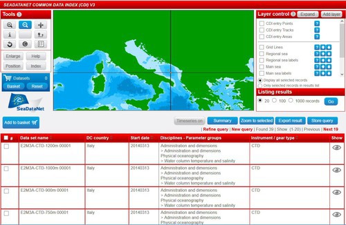
Figure: CDI entries at CDI test portal for E2M3A station of OGS
The user can click on the “Show” button to retrieve a detailed page of the CDI metadata. The user can browse the CDI page downwards to find the data access services. This comprises the normal shopping link to request access to the archived data sets and the new links per parameter to visualize the NRT time series through the client. The user can click on one of the links per parameter to visualize the NRT time series through the client.
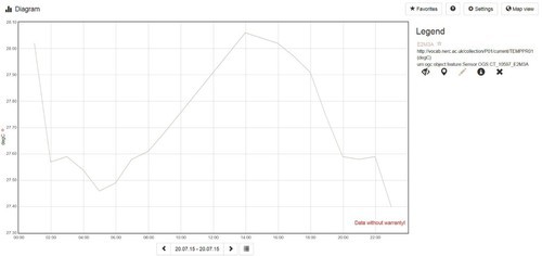
Figure: visualization of the Seawater Temperature at the OGS station at 1200 meters deep.
The demonstrator has successfully shown a possible way to make use of Sensor Web Enablement (SWE) for giving access by visualisation of NRT time series from operational oceanography monitoring stations. This facility can be provided to users of the SeaDataNet CDI service as extension to the regular functionality for browsing metadata and requesting access to the archived data sets. A wider implementation will be evaluated in the near future.
The SeaDataNet architecture has been designed to provide a coherent system of services. For implementation, a range of technical components have been defined and developed. These make use of recent web technologies, and also comprise Java components, to provide multi-platform support. SeaDataNet II has extended the functionalities of the infrastructure and its central portal for users by developing web services for supporting interoperability with other portals. These concern OGC CS-W service for metadata exchange, OpenSearch service for remote queries, and OGC WMS and WFS services for mapping and sharing mapping of the locations and metadata of the CDI entries in the SeaDataNet CDI Data Discovery and Access service.
OGC CS-W provides the option to serve out INSPIRE compliant CDI XML files for wide interoperability with other metadata portals. This concerns metadata while the access to data in case of CDI can be realised by including dynamic URLs towards the SeaDataNet User Interface. The XML output of SeaDataNet CDI service has been upgraded to the new SeaDataNet ISO 19139 Schema and the conversion has been amended by making use of the GEO-DAB brokerage service that also plays an important function for the GEOSS portal. The GEO-DAB brokerage service is operated by CNR and provides SeaDataNet collections as common XML by OAI-PMH service:
http://seadatanet.essi-lab.eu/gi-cat/services/oaipmh?verb=ListIdentifiers&metadataPrefix=ISO19139&set=SEADATANET
and by CS-W service Version 2.0.2 Service – HTTP POST method:
http://seadatanet.essi-lab.eu/gi-cat/services/cswiso
with SEADATANET as parameter for retrieving the SeaDataNet output.
These CS-W and OAI-PMH exchange services have also been used to update the earlier established interoperability from SeaDataNet with the GEOSS portal and the IODE Ocean Data Portal (ODP).
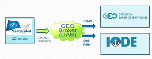
Figure: Established metadata interoperability between SeaDataNet and GEOSS and IODE–ODP portals
OpenSearch is another interesting protocol supported by major portals such as Google, Yahoo, Twitter. The OpenSearch request interface is simple, consisting of a description of a HTTP GET request with a series of optional key-value parameters that can be used to constrain the search: Free search; Geospatial (area or point + radius); Temporal (from to). A SeaDataNet OpenSearch implementation has been developed that considers the full scope of SeaDataNet CDIs. The OpenSearch principle is that so-called OpenSearch entry points are prepared in JSON XML or RDF. Each file describes an access point as an aggregation of the marine data as available in SeaDataNet. To make the entry points not too large in number of CDIs and to provide distinctive attributes to each aggregation of CDIs it has been decided to prepare SeaDataNet entrypoints as aggregations of the CDI observation discipline (code from the SeaDataNet P08 vocabulary), CDI data centre (code from the SeaDataNet EDMO directory), and geometric observation type (point / curve / area) as also done for driving the CS-W exchange (see earlier paragraph). Applying this to the present CDI collection of > 1.8 million CDI entries results in > 480 SeaDataNet OpenSearch entry points. The actual OpenSearch service can be approached by:
http://seadatanet.maris2.nl/opensearch/seadatanet/os_description
This gives the GetCapabilities of the SeaDataNet OpenSearch service.
Another way to achieve interoperability and viewing is making use of the Open Geospatial Consortium (OGC) Web Map Service (WMS) and Web Feature Service (WFS) protocols to exchange metadata including URLs to further metadata and data. WMS makes it possible to share and exchange map layers between internet portals with map viewing services and WFS makes it possible to interrogate the objects on these maps by clicking on those thereby retrieving feature information. The feature info then can include URLs to the associated portal to retrieve further metadata and options to request access and delivery of the data sets. The WMS URL for SeaDataNet is: http://geoservice.maris2.nl/wms/seadatanet/seadatanet
The SeaDataNet WMS GetCapabilities also specifies how the WFS can be called and integrated in another portal. However implementing WFS is depending on the client and needs programming.
Use of common vocabularies in all metadatabases and data formats is an important prerequisite towards consistency and semantic interoperability. Common vocabularies consist of lists of standardised terms that cover a broad spectrum of disciplines of relevance to the oceanographic and wider community. Using standardised sets of terms solves the problem of ambiguities associated with data markup and also enables records to be interpreted by computers. This opens up data sets to a whole world of possibilities for computer aided manipulation, distribution and long term reuse. Common vocabularies have to be controlled for consistency, which includes both content governance (concept population and semantic descriptions) and technical governance (content storage and distribution) services.
BODC has maintained and extended the SeaDataNet controlled vocabularies (NVS 2.0) that provide the basis for semantic interoperability within the SeaDataNet architecture. Maintenance includes both content governance (concept population and semantic descriptions) and technical governance (content storage and distribution) services.
In synergy with EMODnet and ODIP further upgrading of the vocabulary services has been undertaken. One activity is the exposure of the P01 Semantic Model because P01 is composed of multiple components. The semantic model (O&M concept) was agreed and both JSON and RDF representations have been developed. Further work is planned as part of ODIP II to develop the user interfaces to make it easier for data centres to query and identify relevant P01 terms. Users should also be able to propose P01 extensions using a form which can be processed more easily as part of governance. Development of the P01 semantic model was undertaken in consultation with CSIRO (Australia) who also provided feedback on the RDF representation.
Concerning the Semantic Model Exposure activity: primary objective is to build a set of 'one-armed bandit' wheels. The wheels built to date are:
- S02: parameter - matrix relationship (e.g. per unit wet weight of)
- S26: matrix (e.g. Water body [dissolved plus reactive particulate phase])
- S25: biological entity (e.g. Limanda limanda (ITIS: 172881: WoRMS 127139) [Sex: male Subcomponent: liver])
The next steps for the P01 exposure are:
- Development of the 'substance' wheel. Looking at integration of ChEBI into the semantic model with proposed strategy
- Validate/clean ChEBI/CAS mapping mined from eReefs
- Expand P01 semantic model CAS coverage and include as an explicit field. CAS is becoming a very powerful identifier for chemicals.
- Generate mappings between P01 URIs and ChEBI URIs based on CAS (will appear in P01 SKOS documents)
- Development of 'Parameter' wheel which is fairly trivial
- RDF encoding for the exposure of semantic model - draft based on Compound Observable Property (INSPIRE extension to O&M)
- 'Bandit' automated mapping tool
- Research reasoning mapping moderator
These activities will continue in the framework of the ODIP II project.
Concerning Instrument Mapping: the mapping is quite trivial because instruments names are the same. The strategy is to extend the L22 vocabulary to cover all the devices in use by R2R and IMOS. Work is progressing and since August 2014 another 180 native concepts have been added to L22 and now there are 889 instruments described in the vocabulary, providing quite a rich semantic resource. Work will continue as resources become available.
For Parameter Mapping, BODC engaged with ICES in a 'Bandit wheel' mapping exercise for the contaminant in biota database. There are over 800 combinations in ICES (150 for priority biota for EMODnet). As a result 683 new concepts registered in P01 in less than 2 days, it is a very effective way of doing a mapping because rather than looking separate long strings, just pull out the two semantic models and map the semantic models. 8 ‘green dogs’ (invalid model element combinations) were rounded up in the process and eliminated from the ICES data base (Fish with blubber and Mussels with tail muscles).
Concerning SeaDataNet Vocabulary Linkage Issues: a linkage to a vocabulary URI should include a human readable label (included in xlink anchor syntax), a URL (e.g. xlink:href), and information telling the client what to expect at the end of the URL (e.g. xlink:type). Xlink anchor does the job and is becoming popular. SeaDataNet ISO19139 XML documents use ISO codelist linkage. It is therefore rcommended that the next time the schema is revised to add an extra element e.g. Xlink anchor linkages (and keep the ISO codelist as it is). This will be a huge step forward for interoperability.
The NVS 2.0 RESTful interface provides URIs in the form of URLs for each controlled vocabulary (e.g. http://vocab.nerc.ac.uk/collection/P02/) and each controlled vocabulary concept (e.g. http://vocab.nerc.ac.uk/collection/P02/current/TEMP/). The URLs resolve to RDF documents that include content negotiation which makes them human-readable when accessed using a browser whilst remaining machine-readable by applications such as Protégé. The SOAP WSDL may be found at http://vocab.nerc.ac.uk/vocab2.wsdl. The SPARQL endpoint may be queried using the client at http://vocab.nerc.ac.uk/sparql/. Note that this link (and other links to vocab.nerc.ac.uk) may not work with Internet Explorer as the default browser.
The original SeaDataNet search client was built by MARIS and can be found at: http://seadatanet.maris2.nl/v_bodc_vocab_v2/welcome.asp. Recently NERC-BODC has developed a further NVS 2.0 search client
https://www.bodc.ac.uk/data/codes_and_formats/vocabulary_search/
This provides the following additional functionality:
- Vocabulary search in addition to concept search
- Operation off a SPARQL endpoint
- Access to all vocabularies in NVS, not just the SeaDataNet subset
- Advanced user control over search behaviour to allow the hit count to be reduced (especially useful for EMODnet chemistry lot searches in the P01 vocabulary)
- Deprecated concept management
- Ontology browse functionality using all concept mappings in NVS
The SeaDataNet partners have discussed at the last plenary and steering committee meetings the sustainability and future exploitation of the SeaDataNet infrastructure. SeaDataNet is an operationally solid, reliable, efficient semi-distributed ocean data infrastructure that relies on data services provided by the partners. The system has been improved not only in terms of the data and metadata quantity. There has also been an increase in the number of different types of data, data product services, visualisation tools and developed software. An effective monitoring system has been implemented that can detect and report failures that occur in individual data centers allowing a better reliability of the global system.
The EU SeaDataNet II project will contractually end this year; however the infrastructure and services will continue on an operational basis, being the engine also for many other portals, such as a number of EMODnet thematic portals. Furthermore SeaDataNet partners have agreed to continue to maintain the SeaDataNet services and to expand the infrastructure with new data and metadata information for at least the next 3 years. For that purpose a SeaDataNet exploitation agreement has been formulated, which already has been signed by most of the partners.
Recently the EU has launched a new Call for research infrastructures in the HORIZON 2020 programme. This Call includes a topic which has been formulated in dialogue of EU with national representatives and which forms a direct invitation for a substantial SeaDataNet successor project. Preparations are now underway by the SeaDataNet coordinator and technical coordinator together with a few core partners for formulating a first framework for the successor proposal. The new project must include further innovations and uptake of new standards and services in the infrastructure. These innovations will then also benefit EMODnet and other EU projects that make use of the SeaDataNet infrastructure and its standards and services.
The IMDIS (International Conference on Marine Data and Information Systems) is an essential conference for data management. It is intended to provide a forum for discussions between marine data providers and data users as well as representatives of important organisations in the oceanography field like: UNESCO-IOC, FAO, EuroGOOS, EC-JRC, etc. It holds great potential for the ocean science and data management communities to create or reinforce multi sector collaborations.
The previous IMDIS (International Conference on Marine Data and Information Systems) conference, held on 26 – 27 September 2013 in Lucca (Italy) was a great success with 180 participants from 37 Countries. Therefore SeaDataNet has decided to organise another IMDIS 2016 conference, which will be hosted by IOPAN and IMGW in Gdansk - Sopot, Poland, from 11 to 13 October 2016.
CALL FOR PAPERS
The IMDIS series of Conferences is promoting meeting of different communities working in informatics, data management, research, environmental protection, etc. It is focused on on-line access to data, meta-data and products, communication standards and adapted technology to ensure platforms interoperability. IMDIS 2016 aims at providing an overview of the existing information systems on marine environmental data, and showing the progresses on development of efficient infrastructures for managing large and diverse data sets.
The Conference will be organised in four sessions:
- Marine information and data management
- Marine environmental data bases: infrastructures and data access systems
- Data Services in ocean science
- Services for Users and Education
Papers and posters will be selected to present main topics and different technological solutions, and to promote discussions among different communities of developers and users.
ABSTRACT SUBMISSION
Abstracts for oral or poster presentations must be submitted through the IMDIS conference website: http://imdis2016.seadatanet.org/
DEADLINE
Deadline for submission of papers and posters: 13 May 2016.
The European Geosciences Union (EGU) 2016 conference will be held in Vienna on 17 - 22 April 2016. Abstracts are welcome for the session ESSI1.1 Informatics in oceanography and ocean science which is convened by Giuseppe Manzella and Dick M.A. Schaap. The session presents the state of art information systems in oceanography (metadata, vocabularies, ISO and OGC applications, data models), interoperability (Interoperability forms, Web services, Quality of Services, Open standards), data circulation and services (quality assurance / quality control, preservation, network services) and Education in ocean science (Education and Research, Internet tools for education). The 2016 session should provide new ideas on the interoperability issues deriving from different sources of data as well as on metadata quality information. ISO standards introduce the necessary elements in the abstract process aiming to assess ‘how’ and ‘how much’ data meets applicable regulatory requirements and aims to enhance user needs. Data management infrastructures should include an evaluation of data by assuring relevance, reliability and fitness-for-purposes / fitness-for-use, adequacy, comparability and compatibility.
We are kindly inviting you to submit an abstract to the Session Earth & Space Science Informatics (ESSI); Community-driven challenges and solutions dealing with Informatics (ESSI1): Informatics in Oceanography and Ocean Science (ESSI1.1)
Presenters are strongly encouraged to demonstrate how their efforts will benefit their user communities, facilitate collaborative knowledge building, decision making and knowledge management in general, intended as a range of strategies and practices to identify, create, represent and distribute data, products and information.
Link to submit abstracts to ESSI1.1:
http://meetingorganizer.copernicus.org/EGU2016/session/20136
Detailed information on how to submit an abstract can be found at:
http://egu2016.eu/abstract_management/how_to_submit_an_abstract.html
Deadline for Abstract submission: 3 January 2016 !!
We wish Dr Roy Lowry, technical director of BODC, all the best in his retirement. And we like to thank him for all the brilliant work and exceptional dedication to SeaDataNet that he has displayed so far. His contributions have provided a strong basis which will continue.
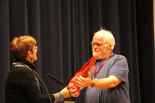
Figure: SeaDataNet project coordinator, Michele Fichaut, and Roy Lowry (image by Serge Scory)
This newsletter contains many acronyms which are described in the following list:
CDI: Common Data Index
CSR: Cruise Summary Reports
CS-W: Catalog Service for the Web
EDIOS: European Directory of Oceanographic Observing Systems
EDMED: European Directory of Marine Environmental Data
EDMERP: European Directory of Marine Environmental Research Projects
EDMO: European Directory of Marine Organisations
EMODnet: European Marine Observation and Data Network
FP6: Sixth Framework Programme
FP7: Seventh Framework Programme
IOC: Intergovernmental Oceanographic Commission
IODE: International Oceanographic Data and Information Exchange
NMF: National Marine Facility
NODC: National Oceanographic Data Centre
ODIP: Ocean Data Interoperability Platform
ODSBP: Ocean Data Standards and Best Practices Project
OGC: Open Geospatial Consortium
POGO: Partnership for Observation of the Global Oceans
QC: Quality Control
RCs: Regional Climatologies
RMSE: Root Means Square Root
R2R: Rolling Deck to Repository
SDN: SeaDataNet
SWE: OGC Sensor Web Enablement
WOA13: World Ocean Atlas 2013
XML: Extensible Markup Language


